 Filter: Categories of Wisconsin Historical Images
Filter: Subject of Mounds
Filter: Subject of intellectual life
Filter: Subject of hills
Filter: Categories of Wisconsin Historical Images
Filter: Subject of Mounds
Filter: Subject of intellectual life
Filter: Subject of hills
| Date: | |
|---|---|
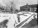
| Description: | A turtle effigy mound on the University of Wisconsin-Madison campus, outlined by melting snow. |
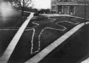
| Date: | 1910 |
|---|---|
| Description: | Elevated view of a double-tailed turtle effigy mound on Observatory Hill on the University of Wisconsin-Madison campus. |

| Date: | 1851 |
|---|---|
| Description: | Map of a portion of Merton including the Bark River, a mill, Fort Hill, and Indian mounds. |

| Date: | 1864 |
|---|---|
| Description: | This map is pen and watercolor on paper and shows a profile and geological sections of the Blue Mounds, Hollow Run, Bogies Hollow Run, Bear Creek, East Bre... |

| Date: | 1864 |
|---|---|
| Description: | This map is pen and watercolor on paper and shows a profile and geological sections of the Spensley Break, James Break, Wisconsin River, and Little Bear Cr... |

| Date: | 1864 |
|---|---|
| Description: | This map is pen and pencil on paper and shows a profile of the Blue Mound and East Blue Mound. |

| Date: | 1930 |
|---|---|
| Description: | Poppies are blooming in a large field with a hill in the background. The photographer identifies the hill as a shell mound. The shell mound is likely the l... |

| Date: | 11 03 1903 |
|---|---|
| Description: | A drawing of a group of burial mounds in Linden Valley. Text on back reads: "These mounds lie at the narrow mouth of Linden Valley on the east side of the ... |
If you didn't find the material you searched for, our Library Reference Staff can help.
Call our reference desk at 608-264-6535 or email us at: