 Filter: Categories of Wisconsin Historical Images
Filter: Subject of Mounds
Filter: Subject of intellectual life
Filter: Subject of transportation
Filter: Categories of Wisconsin Historical Images
Filter: Subject of Mounds
Filter: Subject of intellectual life
Filter: Subject of transportation

| Date: | 06 27 1927 |
|---|---|
| Description: | Aerial view of the effigy mound on Henry Wehmhoff's Riverview Farm. State Trunk Highway 83 runs through the effigy. |
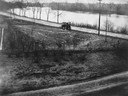
| Date: | 1905 |
|---|---|
| Description: | View of an Indian intaglio effigy, the only one still in existence in Wisconsin. The effigy is in the shape of a panther. There is a car on the road in the... |
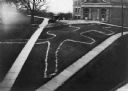
| Date: | 1910 |
|---|---|
| Description: | Elevated view of a double-tailed turtle effigy mound on Observatory Hill on the University of Wisconsin-Madison campus. |
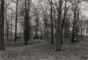
| Date: | 1938 |
|---|---|
| Description: | A field party lead by Charles E. Brown prepare to excavate the Heim effigy mound. The effigy, shaped like a fox or wolf, has been outlined by stakes. The m... |

| Date: | 1924 |
|---|---|
| Description: | This pictorial map focuses on the Madison Isthmus, Lake Mendota, Lake Monona, Lake Wingra, and shows points of historical interest, buildings, parks, and I... |

| Date: | 01 1969 |
|---|---|
| Description: | A map of Oneida county, which includes a small drawing of a hodag. |

| Date: | 1925 |
|---|---|
| Description: | This map shows trails, mounds, villages, corn fields, and contemporary civil townships; some villages and features include both Indian and English place na... |

| Date: | 11 03 1903 |
|---|---|
| Description: | A drawing of a group of burial mounds in Linden Valley. Text on back reads: "These mounds lie at the narrow mouth of Linden Valley on the east side of the ... |
If you didn't find the material you searched for, our Library Reference Staff can help.
Call our reference desk at 608-264-6535 or email us at:
