 Filter: Categories of Wisconsin Historical Images
Filter: Subject of Mounds
Filter: Subject of intellectual life
Filter: Categories of Wisconsin Historical Images
Filter: Subject of Mounds
Filter: Subject of intellectual life

| Date: | |
|---|---|
| Description: | Ink and watercolor of prehistoric mounds near the mouth of Haigs Creek and the Scioto River. |

| Date: | 1851 |
|---|---|
| Description: | Diagram of an effigy mound in the shape of a cross. |

| Date: | 1851 |
|---|---|
| Description: | Map of a portion of Merton including the Bark River, a mill, Fort Hill, and Indian mounds. |

| Date: | 1916 |
|---|---|
| Description: | In 1916, it was estimated that 15,000 Indian mounds had formerly existed in Wisconsin. In the early 20th century, the Wisconsin Archaeological Society surv... |

| Date: | |
|---|---|
| Description: | A hand-colored geological cross section of Iowa County and eastern Dane County, Wisconsin, from the Blue Mounds north-northwest to the sandy plain of the W... |

| Date: | 1924 |
|---|---|
| Description: | This pictorial map focuses on the Madison Isthmus, Lake Mendota, Lake Monona, Lake Wingra, and shows points of historical interest, buildings, parks, and I... |

| Date: | 01 1969 |
|---|---|
| Description: | A map of Oneida county, which includes a small drawing of a hodag. |
| Date: | 05 31 1935 |
|---|---|
| Description: | Students digging into a bird effigy mound on the University of Wisconsin campus on May 31 through June 1, 1935. |

| Date: | 06 1911 |
|---|---|
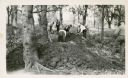
| Description: | A field party of members of the Wisconsin Archaeological Society visit an effigy mound at Big Bend. The men are dressed in suits and hats. |

| Date: | 1864 |
|---|---|
| Description: | This map is pen and watercolor on paper and shows a profile and geological sections of the Blue Mounds, Hollow Run, Bogies Hollow Run, Bear Creek, East Bre... |

| Date: | 1864 |
|---|---|
| Description: | This map is pen and watercolor on paper and shows a profile and geological sections of the East Blue Mound Break, Blue Mound Creek, Black Earth River, and ... |

| Date: | 1864 |
|---|---|
| Description: | This map is pen and watercolor on paper and shows a profile and geological sections of the Apple River, Little Otter Creek, Woods' Branch, Bonners' Branch,... |

| Date: | 1864 |
|---|---|
| Description: | This map is pen and watercolor on paper and shows a profile and geological sections of the Spensley Break, James Break, Wisconsin River, and Little Bear Cr... |

| Date: | 1864 |
|---|---|
| Description: | This map is pen and pencil on paper and shows a profile of the Blue Mound and East Blue Mound. |

| Date: | 1864 |
|---|---|
| Description: | This map is pen and pencil on paper and shows a profile of the Blue Mound and East Blue Mound. |

| Date: | 1925 |
|---|---|
| Description: | This map shows trails, mounds, villages, corn fields, and contemporary civil townships; some villages and features include both Indian and English place na... |

| Date: | 01 12 2016 |
|---|---|
| Description: | Save the Mounds demonstration around the Capitol Square against Assembly Bill 620. View looking up at the Flag and Standard bearers lined up behind the spe... |

| Date: | 01 12 2016 |
|---|---|
| Description: | Save the Mounds demonstration around the Capitol Square against Assembly Bill 620. View from behind Joanne Jones of the Ho Chunk Nation, speaker, standing ... |

| Date: | 01 12 2016 |
|---|---|
| Description: | Save the Mounds demonstration around the Capitol Square against Assembly Bill 620. Chief Clayton Winneshiek of the Ho Chunk Nation, wearing a headdress, is... |
If you didn't find the material you searched for, our Library Reference Staff can help.
Call our reference desk at 608-264-6535 or email us at:
