 Filter: Categories of Wisconsin Historical Images
Filter: Subject of Mounds
Filter: Subject of roads
Filter: Categories of Wisconsin Historical Images
Filter: Subject of Mounds
Filter: Subject of roads

| Date: | 06 27 1927 |
|---|---|
| Description: | Aerial view of the effigy mound on Henry Wehmhoff's Riverview Farm. State Trunk Highway 83 runs through the effigy. |

| Date: | 1915 |
|---|---|
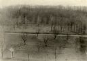
| Description: | A row of conical burial mounds adjoins the Park and Pleasure Drive on the north shore of Lake Wingra (now Edgewood Drive, at the south edge of Edgewood Col... |
| Date: | |
|---|---|
| Description: | Elevated view of Man Mound outlined in chalk looking south. A road bisects the legs of the effigy mound. A small outbuilding can be seen at left in the for... |

| Date: | |
|---|---|
| Description: | Map of Baraboo and its surroundings, showing the ancient mound city, the water power, and thoroughfares, drawn by William H. Canfield. Canfield includes sk... |

| Date: | 1844 |
|---|---|
| Description: | Part of a series of local maps, showing a number of burial mounds in the shape of animals near Madison, Wisconsin along military road. The maps also show d... |

| Date: | 1931 |
|---|---|
| Description: | This map of south central Wisconsin shows lakes, rivers, cities, villages, highways and roads, railroads, Indian mounds, and points of scenic and historic ... |

| Date: | 1920 |
|---|---|
| Description: | A map of the Nelson-Dewey State Park at the confluence of the Mississippi and Wisconsin rivers, showing the topographical features of the area, as well as ... |

| Date: | 1920 |
|---|---|
| Description: | This 1920 map actually depicts present-day Wyalusing State Park at the confluence of the Mississippi and Wisconsin rivers in the Town of Wyalusing, Grant C... |

| Date: | 1915 |
|---|---|
| Description: | This 1915 map covers portions of Barron, Chippewa, and Rusk counties in Wisconsin. Shown are the township and range grid, sections, cities and villages, ra... |

| Date: | 1974 |
|---|---|
| Description: | This 1974 map is a reproduction of the original survey maps of the Four Lakes region of Dane County, Wisconsin. It shows sections, lakes, rivers, wetlands,... |

| Date: | 1970 |
|---|---|
| Description: | This pictorial map of Dunn County, Wisconsin, from the 1970s depicts historical events that occurred in the county. It shows cemeteries, churches, schools,... |

| Date: | 1859 |
|---|---|
| Description: | Shows townships and sections, landownership, roads, railroads, rural residences, schools, churches, and topography. Relief shown by hachures. "From governm... |

| Date: | 1873 |
|---|---|
| Description: | A map of the township of Primrose from the "Atlas of Dane County." |

| Date: | 1945 |
|---|---|
| Description: | This maps shows roads, railroads, parks, recreational areas, Lake Wingra, Lake Monona, and part of Lake Mendota. The map includes pictorial images that dep... |

| Date: | 10 1911 |
|---|---|
| Description: | This map shows lot numbers, building lines, roads, trees, and Indian mounds. Relief is shown by contours. Includes manuscript annotations marking parks. |

| Date: | 1919 |
|---|---|
| Description: | Narrow red lines show principal secondary highways. Green circles shows points of historical interest. Green triangles show Indian mounds and Indian villag... |

| Date: | 1861 |
|---|---|
| Description: | This map shows townships and sections, landownership, roads, railroads, rural residences, schools, churches, and topography. Also included are inset maps o... |

| Date: | 1864 |
|---|---|
| Description: | This map shows locations of quarries, sink holes, creeks, springs, rivers, houses, forts, and roads. Annotations in pencil read: "Is the top of the mound l... |

| Date: | 06 2008 |
|---|---|
| Description: | View looking east of a 1000-year-old Indian intaglio effigy in the shape of a panther. The effigy, which is on the north bank of the Rock River, is filled ... |

| Date: | 1944 |
|---|---|
| Description: | Portage County Map. Includes the towns of Eau Plaine, Dewey, Sharon, Alban, Carson, Hull, New Hope, Linwood, Stockton, Amherst, Plover, Grant, Buena Vista,... |
If you didn't find the material you searched for, our Library Reference Staff can help.
Call our reference desk at 608-264-6535 or email us at: