 Filter: Categories of Wisconsin Historical Images
Filter: Subject of Mounds
Filter: Year of 1900-1999
Filter: Categories of Wisconsin Historical Images
Filter: Subject of Mounds
Filter: Year of 1900-1999

| Date: | 1945 |
|---|---|
| Description: | This maps shows roads, railroads, parks, recreational areas, Lake Wingra, Lake Monona, and part of Lake Mendota. The map includes pictorial images that dep... |
| Date: | 1905 |
|---|---|
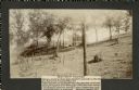
| Description: | Two of a series of three large platform mounds on the top of a high hill, overlooking the Mississippi and Black River valleys. Two young children are seate... |
| Date: | 1905 |
|---|---|
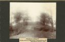
| Description: | View across top of platform mound on the crest of a high hill. Trees are on the left and right. In the background below is the Mississippi River. |

| Date: | 10 1911 |
|---|---|
| Description: | This map shows lot numbers, building lines, roads, trees, and Indian mounds. Relief is shown by contours. Includes manuscript annotations marking parks. |

| Date: | 01 1969 |
|---|---|
| Description: | A map of Oneida county, which includes a small drawing of a hodag. |

| Date: | 1919 |
|---|---|
| Description: | Narrow red lines show principal secondary highways. Green circles shows points of historical interest. Green triangles show Indian mounds and Indian villag... |
| Date: | 05 31 1935 |
|---|---|
| Description: | Students digging into a bird effigy mound on the University of Wisconsin campus on May 31 through June 1, 1935. |

| Date: | 07 30 1910 |
|---|---|
| Description: | Group of people standing on an eagle effigy mound on State Hospital grounds. |

| Date: | 06 1911 |
|---|---|
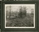
| Description: | A field party of members of the Wisconsin Archaeological Society visit an effigy mound at Big Bend. The men are dressed in suits and hats. |
| Date: | 10 16 1910 |
|---|---|
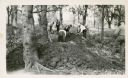
| Description: | View of a linear Indian mound at Big Bend. Two men stand in the background on the left and right among the trees. |

| Date: | 06 30 1910 |
|---|---|
| Description: | People gathered for a ceremony at the unveiling of a marker at an eagle effigy mound on the State Hospital Grounds. |

| Date: | 1925 |
|---|---|
| Description: | This map shows trails, mounds, villages, corn fields, and contemporary civil townships; some villages and features include both Indian and English place na... |

| Date: | 1900 |
|---|---|
| Description: | This photocopy map shows marshes, woods, buildings, and selected features including islands, mounds, old Fort Crawford, and "new site for a fort in questio... |

| Date: | 1930 |
|---|---|
| Description: | Poppies are blooming in a large field with a hill in the background. The photographer identifies the hill as a shell mound. The shell mound is likely the l... |

| Date: | 05 23 1958 |
|---|---|
| Description: | Construction begins on Spring Harbor School, 1110 Spring Harbor Drive just north of University Avenue. The building was designed by Kaeser and McLeod Archi... |

| Date: | 05 26 1906 |
|---|---|
| Description: | The Wisconsin Archeological Society attending the unveiling of the Cutler Indian mound marker at Cutler Park. Mrs. William H. Anderson, President (?) of th... |

| Date: | 06 30 1939 |
|---|---|
| Description: | A drawing of a lizard-shaped Indian mound at Hudson Park. |

| Date: | 1944 |
|---|---|
| Description: | Portage County Map. Includes the towns of Eau Plaine, Dewey, Sharon, Alban, Carson, Hull, New Hope, Linwood, Stockton, Amherst, Plover, Grant, Buena Vista,... |

| Date: | 1901 |
|---|---|
| Description: | Plat map showing land ownership of Township 21N Range 3W in Jackson County for 1901. Scale is 2 inches to 1 mile. |
If you didn't find the material you searched for, our Library Reference Staff can help.
Call our reference desk at 608-264-6535 or email us at:
