 Filter: Categories of Wisconsin Historical Images
Filter: Subject of Mounds
Filter: Year of 1900-1999
Filter: Year of 1940-1949
Filter: Categories of Wisconsin Historical Images
Filter: Subject of Mounds
Filter: Year of 1900-1999
Filter: Year of 1940-1949
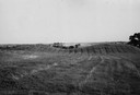
| Date: | 1945 |
|---|---|
| Description: | Field with contours, and two mounds. |
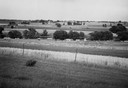
| Date: | 1945 |
|---|---|
| Description: | Field prior to the park's reconstruction, with a fence in the foreground. A river is at the bottom of the hill. |
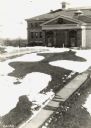
| Date: | 09 28 1942 |
|---|---|
| Description: | Elevated view of turtle mound on the University of Wisconsin-Madison campus. |

| Date: | 1941 |
|---|---|
| Description: | This pictorial map shows sites related to Indian legends, mounds, and trails in the Chain O' Lakes region in southwestern Waupaca County, Wisconsin. |

| Date: | 1945 |
|---|---|
| Description: | This maps shows roads, railroads, parks, recreational areas, Lake Wingra, Lake Monona, and part of Lake Mendota. The map includes pictorial images that dep... |

| Date: | 1944 |
|---|---|
| Description: | Portage County Map. Includes the towns of Eau Plaine, Dewey, Sharon, Alban, Carson, Hull, New Hope, Linwood, Stockton, Amherst, Plover, Grant, Buena Vista,... |
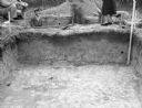
| Date: | 11 01 1947 |
|---|---|
| Description: | View across an excavation toward men and women standing above and behind it. Men are in another excavated hole behind it. Caption reads: "Excavation in cir... |
If you didn't find the material you searched for, our Library Reference Staff can help.
Call our reference desk at 608-264-6535 or email us at: