 Filter: Categories of Wisconsin Historical Images
Filter: Subject of Mountains
Filter: Type of Map or Atlas
Filter: Categories of Wisconsin Historical Images
Filter: Subject of Mountains
Filter: Type of Map or Atlas

| Date: | 1755 |
|---|---|
| Description: | Map of the Great Lakes region during the French and Indian War. It shows in great detail the territories, borders and boundary lines, Native American tribe... |
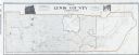
| Date: | 1909 |
|---|---|
| Description: | A map of Lewis County, Washington. There are two photographs at the top, an exterior and interior view of the bank building of Coffman, Dobson, & Co. Banke... |
If you didn't find the material you searched for, our Library Reference Staff can help.
Call our reference desk at 608-264-6535 or email us at: