 Filter: Categories of Wisconsin Historical Images
Filter: Subject of Mountains
Filter: Creator Name of Unknown
Filter: Categories of Wisconsin Historical Images
Filter: Subject of Mountains
Filter: Creator Name of Unknown
| Date: | |
|---|---|
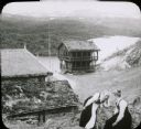
| Description: | View of a mountaintop house and other buildings with sod roofs. Two women, who are possibly Swiss or Norwegian, are in the foreground sitting on a steep hi... |

| Date: | |
|---|---|
| Description: | Elevated view of one man and two women tending the cows near a farm building at a dairy farm in Vide Saeter, Norway. The Vide Valley is in the background. |

| Date: | |
|---|---|
| Description: | Two Norwegians milkmaids stand together on Grjotlid Road, holding cans of milk on yokes around their necks. They are standing at the edge of a steep hill, ... |
| Date: | |
|---|---|
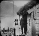
| Description: | A farming couple pose together on the steps of a building with a sod roof in Nordfjord country. In the background is a lake and a mountain on the far shore... |

| Date: | 1910 |
|---|---|
| Description: | View of Table Mountain and beach from Milnerton, South Africa. People are walking on the beach. |

| Date: | 1910 |
|---|---|
| Description: | Elevated street view of Cape Town, South Africa. Wagons, cars, people, and animals can be seen in the streets, and mountains in the background. |

| Date: | 1910 |
|---|---|
| Description: | External view of the Parliament house in Cape Town, South Africa. In the background are mountains. |

| Date: | 1910 |
|---|---|
| Description: | City Hall in Cape Town, South Africa. In the background are mountains. |

| Date: | 1910 |
|---|---|
| Description: | Log and thatched homes. In a number of her journals, Carrie describes the conditions of housing. Many countries at the time still utilized thatched houses ... |

| Date: | 1910 |
|---|---|
| Description: | A group of children gathered on a rock. There is a mountain in the background. Carrie describes in multiple journals that children were rarely fully clothe... |

| Date: | 1776 |
|---|---|
| Description: | This was one of the first maps available for the general British populace featuring America during the Revolutionary War. It includes forts, cities, topogr... |

| Date: | 1782 |
|---|---|
| Description: | Map of the West Indies and south eastern North America, remarkably detailed, showing cities, mountains, rivers, lakes, mines, plantations, forts, banks, an... |

| Date: | 1790 |
|---|---|
| Description: | This map of the north eastern states shows roads, rivers, lakes, waterfalls, mountains, cities, forts, mills, the Oneida Reservation, and "New York Donatio... |

| Date: | 1871 |
|---|---|
| Description: | A map of California showing railroad lines and reservations. |

| Date: | 1790 |
|---|---|
| Description: | Map of North America showing cities, states, Native American land, regions, lakes, and rivers. A few notes appear throughout the map, particularly west of ... |

| Date: | 1763 |
|---|---|
| Description: | Map of America and part of Canada including the borders of European claims after the French and Indian War. Cities, forts, Native American lands, rivers, l... |

| Date: | 1776 |
|---|---|
| Description: | Map of the American colonies and land east of the Mississippi River. Prominent cities, forts, Native American land, mountains, rivers and lakes are all sho... |

| Date: | 1782 |
|---|---|
| Description: | Map of America east of the Mississippi River. It shows regions, state boundaries extending to the Mississippi River, cities, forts, Native American lands, ... |

| Date: | 1755 |
|---|---|
| Description: | Map of the northeastern portion of America and Canada, east of the Hudson River and south from Labrador. It names regions, colonies, cities, numerous forts... |

| Date: | 1780 |
|---|---|
| Description: | Detailed map of America east of the Louisiana region. It shows forts, cities, borders and boundary lines, Native American land, the post road, mountains, w... |
If you didn't find the material you searched for, our Library Reference Staff can help.
Call our reference desk at 608-264-6535 or email us at: