 Filter: Categories of Wisconsin Historical Images
Filter: Subject of Mountains
Filter: Subject of water
Filter: Categories of Wisconsin Historical Images
Filter: Subject of Mountains
Filter: Subject of water
| Date: | |
|---|---|
| Description: | Elevated view of dredging operations at the mouth of Bear Creek in Canada. Caption reads: "Dredging Operations at the Mouth of Bear Creek, Dawson, Y.T." |
| Date: | |
|---|---|
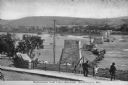
| Description: | Slightly elevated view of several people overlooking a bridge under construction. Caption reads: "Building The New Bridge, Berwick, PA." |
| Date: | |
|---|---|
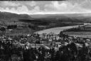
| Description: | Elevated view of country town showing large. There are wooden buildings alongside the Delaware River which curves through fields and patches of woods in th... |
| Date: | |
|---|---|
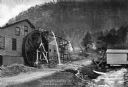
| Description: | View toward a mill with a large water wheel and spring branch, near King Solomon's Cave. A man is posed standing next to the middle of the water wheel. Cap... |
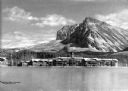
| Date: | |
|---|---|
| Description: | Columbia Mill, established in 1827, is shown surrounded by a landscape featuring a lake and wooded mountain. The mill is the site where the first successfu... |

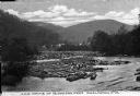
| Date: | |
|---|---|
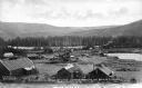
| Description: | Elevated view of a small settlement between two mountains and alongside a river with tracks of the first transcontinental railroad passing through. A bridg... |
| Date: | |
|---|---|
| Description: | Elevated view of logs in the river. Near the river's bend are houses and other structures. The rolling hills and forests of West Virginia are in the backgr... |

| Date: | |
|---|---|
| Description: | Elevated view of a town and body of water in a valley in Roldal, Norway. Two people in a horse-drawn vehicle are in the foreground on the road leading from... |
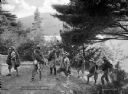
| Date: | |
|---|---|
| Description: | A group of campers hikes through the woods while carrying their bedrolls and camping equipment. The view features trees, a mountain, and a lake in the bac... |
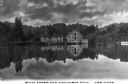
| Date: | |
|---|---|
| Description: | View of the Glacier Park Hotel from across Lake McDermott. View features the hotel surrounded by forest with a mountain in the background. |
| Date: | |
|---|---|
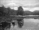
| Description: | Girls canoe near a dock at Camp Lenoloc as additional girls watch from the shoreline. Trees and other foliage line the water and mountains are in the backg... |
| Date: | |
|---|---|
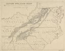
| Description: | "Non-agricultural land in southern Appalachian Mountains" |

| Date: | 1930 |
|---|---|
| Description: | Pictorial map of Glacier National Park, Montana and Waterton Lakes National Park, Alberta. Illustrated by Joe Scheurle, it depicts white people, American ... |

| Date: | 1930 |
|---|---|
| Description: | The back of the pictorial map titled Recreational Map of Glacier National Park, Montana: Waterton Lakes National Park, Alberta. 14 panels of text and photo... |

| Date: | 11 26 1883 |
|---|---|
| Description: | A hand-drawn map of the Clinch and Powell's Valleys, including the Cumberland Mountains, Powell's Mountains and Clinch Mountains. |

| Date: | |
|---|---|
| Description: | A hand-drawn map of Indian boundary lines in southwest Virginia. It also includes the Duck River and the Elk River. |
| Date: | 1866 |
|---|---|
| Description: | View towards the Allatoona Pass from behind earthworks overlooking the Etawah River. A railroad bridge crosses the river on the right. Plate 24 |

| Date: | 1866 |
|---|---|
| Description: | View along earthworks overlooking the Etawah River and a railroad bridge. A tree stripped of branches and bark is on the left. Plate 23 |
| Date: | 1866 |
|---|---|
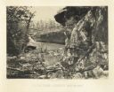
| Description: | Cliffs along Lu-la Lake. A waterfall is in the background. Plate 15 |
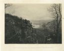
| Date: | 1866 |
|---|---|
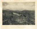
| Description: | Elevated view of the Chattanooga Valley, with a river in the far background. A cliff face and trees are in the foreground. Plate 14 |
If you didn't find the material you searched for, our Library Reference Staff can help.
Call our reference desk at 608-264-6535 or email us at: