 Filter: Categories of Wisconsin Historical Images
Filter: Subject of Municipal services
Filter: Subject of water-supply
Filter: Categories of Wisconsin Historical Images
Filter: Subject of Municipal services
Filter: Subject of water-supply
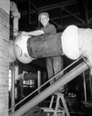
| Date: | 11 20 1933 |
|---|---|
| Description: | John Hines dismantling one of two out-of-date pumps at the Madison Water Works, 311 N. Hancock Street, a job he obtained through the CWA (Civil Works Admin... |

| Date: | 06 12 1944 |
|---|---|
| Description: | Portrait of Leon A. Smith, Madison's water superintendent since 1916. |
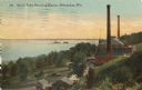
| Date: | 1910 |
|---|---|
| Description: | Elevated view from hill toward the building which has two large smokestacks. The Lake Michigan shoreline is on the left. In front is a landscaped area with... |
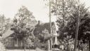
| Date: | 1945 |
|---|---|
| Description: | Exterior view of the stone-walled headquarters building of the Water Regulatory Board located within a grove of trees. According to text included with the ... |
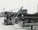
| Date: | 1946 |
|---|---|
| Description: | International I-4 industrial tractor with crane owned by the Milwaukee Waterworks. Original caption reads: "The city of Milwaukee, Wisconsin, purchased thi... |
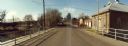
| Date: | 11 16 1989 |
|---|---|
| Description: | View from the Water Street Bridge over the Waupaca River toward the Waupaca Water Department. |
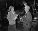
| Date: | 02 20 1950 |
|---|---|
| Description: | League of Women Voters member Mrs. Frederick (Priscilla) Greeky interviews Leon A. Smith, superintendent of Madison's Water Department, as part of the leag... |
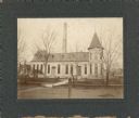
| Date: | 1910 |
|---|---|
| Description: | The Madison waterworks building, with corner tower and turret. The building was located at the corner of Gorham and Livingston Streets. The large smokesta... |

| Date: | 1880 |
|---|---|
| Description: | This map is pen-and-ink on paper. The map shows buildings, trees, and water and gas pipes, relief is shown by contours. The back of the map reads: "Univers... |

| Date: | 1887 |
|---|---|
| Description: | Shows pipes of various sizes, hydrants with hydrant pressure, valves, wells, and projected lines. |

| Date: | 1892 |
|---|---|
| Description: | Shows pipes of various sizes, hydrants with hydrant pressure, valves, wells, and projected lines. Differs from earlier versions by inclusion of Wingra Park... |

| Date: | 1896 |
|---|---|
| Description: | Shows pipes of various sizes, hydrants with hydrant pressure, valves, wells, projected lines, and suction pipes. Differs from earlier versions by inclusion... |

| Date: | 1908 |
|---|---|
| Description: | Shows pipes of various sizes, hydrants, valves, and wells. "1907" -- Lower margin. Lake Wingra, Lake Monona, and Lake Mendota are labelled. |

| Date: | 1894 |
|---|---|
| Description: | This map shows lot and block numbers, railroads, street car tracks, sewers, water mains, gas mains, paved streets, land owned by the Land & River Improveme... |

| Date: | 1892 |
|---|---|
| Description: | This map shows water pipes, hydrants, stop cocks, check valves, fire cysterns, and manholes. Also shown are block numbers, streets, railroads, parks, cemet... |
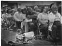
| Date: | 06 30 1989 |
|---|---|
| Description: | Many people are sitting on folding chairs. An infant is sitting on a blanket on the floor next to them and playing with stacking cups. Caption reads: "TOYI... |
If you didn't find the material you searched for, our Library Reference Staff can help.
Call our reference desk at 608-264-6535 or email us at: