 Filter: Categories of Wisconsin Historical Images
Filter: Subject of Ocean
Filter: Subject of land
Filter: Creator Name of Unknown
Filter: Categories of Wisconsin Historical Images
Filter: Subject of Ocean
Filter: Subject of land
Filter: Creator Name of Unknown
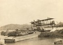
| Date: | 1912 |
|---|---|
| Description: | A Curtiss hydroaeroplane tied down prior to a test flight over San Diego Bay. Two unidentified pilots rest on the dock in the shade of its wing. |

| Date: | 1877 |
|---|---|
| Description: | Map showing location of Indian reservations in the United States and population figures. |
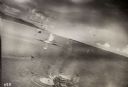
| Date: | 10 22 1943 |
|---|---|
| Description: | View across water of Mushu Island in the distance. There is a ship in the foreground, an airplane above, and the appearance of explosions in the water. |
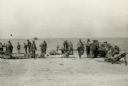
| Date: | 11 13 1942 |
|---|---|
| Description: | Headquarters of the 32nd American Division, on the beach at Pongani, northeast New Guinea. |

| Date: | |
|---|---|
| Description: | Panoramic collotype of Havana, Cuba harbor. Numerous boats are visible. Sky appears to have been masked out before printing. |

| Date: | 1784 |
|---|---|
| Description: | Map of The United States of America according to the Treaty of Peace of 1784. |

| Date: | |
|---|---|
| Description: | Elevated view of grid-plotted farm fields with a few cows grazing. The ocean is visible in the background. |

| Date: | |
|---|---|
| Description: | View across shrubs toward a stone historical marker dedicated to Champlain, a Canadian explorer. The marker overlooks the ocean, and a sailboat is visible ... |
| Date: | |
|---|---|
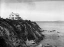
| Description: | View of the Bonnet Shores Club atop a cliff overlooking the ocean. |
| Date: | |
|---|---|
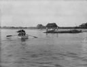
| Description: | View across water toward the shore. People are rowing a boat in the foreground, and people are standing on a rock near the shore. In the background are hou... |
| Date: | |
|---|---|
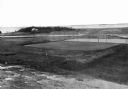
| Description: | Elevated view of golf links featuring Squaw Island in the distance. |
| Date: | 1930 |
|---|---|
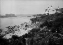
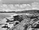
| Description: | View along top of rocky cliff toward a home on the right overlooking the ocean, with a large building further down the curving shoreline in the distance. |
| Date: | 1940 |
|---|---|
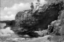
| Description: | View of Anemone Cave and crashing waves, surrounded by coastal rock formations. |
| Date: | 1925 |
|---|---|
| Description: | View along rocky coastline with crashing waves. Buildings are along the shoreline in the distance. Caption reads: "View from Ye Headland Inn. Trefethen, Ma... |
| Date: | 1920 |
|---|---|
| Description: | View along top of cliff toward cottages along a rocky coast. A large building is in the distance on the right. |
| Date: | |
|---|---|
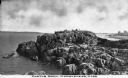
| Description: | Elevated view of Castle Rock, located on the coast, with numerous people looking out over the water. Caption reads: "Castle Rock, Marblehead, Mass." |
| Date: | |
|---|---|
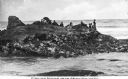
| Description: | Elevated view across water toward large rocks from which people are fishing. Caption reads: "Fishing Rocks, Near Seaview, Wash." |

| Date: | 1920 |
|---|---|
| Description: | View across harbor filled with boats toward small wooden cottages along the far shoreline. A rock wall along the water's edge is in the foreground on the r... |
| Date: | 1920 |
|---|---|
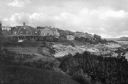
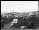
| Description: | Elevated view from hill looking down toward buildings in the hills along the coast. |

| Date: | |
|---|---|
| Description: | Elevated view of village homes on the shores of the bay with docked fishing boats in the foreground. Caption reads, "Marblehead, Mass from Rockmere Point." |
If you didn't find the material you searched for, our Library Reference Staff can help.
Call our reference desk at 608-264-6535 or email us at: