 Filter: Categories of Wisconsin Historical Images
Filter: Subject of Ocean
Filter: Subject of land
Filter: Categories of Wisconsin Historical Images
Filter: Subject of Ocean
Filter: Subject of land
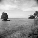
| Date: | 02 28 1945 |
|---|---|
| Description: | Robert Doyle notes, "Strange island near Pago Pago." He was on Tutuila Island, in American Samoa, in the South Pacific. Palm trees are growing on the shore... |
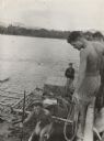
| Date: | 1943 |
|---|---|
| Description: | Small fishing vessels carried supplies for troops marching up the coast towards Buna, New Guinea (present day Papua New Guinea). Here soldiers lower cases ... |
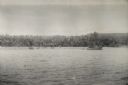
| Date: | 1942 |
|---|---|
| Description: | View over water towards the New Guinea coast from a boat. A larger boat is on the right and several smaller craft in the center. A pier is on the shoreline... |

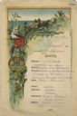
| Date: | 07 21 1925 |
|---|---|
| Description: | Dinner menu from the Hotel St. Catherine, with a color postcard at the top, meant to be detached and mailed, with a view of the hotel against a backdrop of... |

| Date: | 1967 |
|---|---|
| Description: | Black and white photographic greeting card. View down beach towards couple hugging while standing in the sand. The word "love" is centered at the top. |

| Date: | 1927 |
|---|---|
| Description: | A switchback path leading to Cap Carbon and the lighthouse perched near the summit of the peninsula. The lighthouse is built on top of a giant rock that pr... |

| Date: | 1720 |
|---|---|
| Description: | Double hemispherical world map showing routes of Tasman, Magellan, Mendana, etc. Relief shown pictorially. Title in oak wreath cartouche. Map between four ... |

| Date: | 1740 |
|---|---|
| Description: | From Weigel's Atlas portatilis, oder, Compendieuse Vorstellung der gantzen Welt. Map of Europe. |

| Date: | 1712 |
|---|---|
| Description: | Engraved double-hemispherical world map by Moll, included in his atlas The world described, or, A new and correct sett of maps: shewing the kingdoms and st... |

| Date: | 1696 |
|---|---|
| Description: | Engraved and hand-colored map of Ethiopia, from Blaeu's General Atlas. Map title is framed by a man and a woman, both wearing head turbans, who are standin... |

| Date: | 1798 |
|---|---|
| Description: | Engraved and hand-colored map of Egypt. Map title appears on bottom left as a carving in stone next ... |

| Date: | 1740 |
|---|---|
| Description: | Engraved and hand-colored map of the Iberian peninsula as a theater of war during the War of the Spanish Succession (1701-1714). The map is dedicated to Ki... |

| Date: | 1785 |
|---|---|
| Description: | Map of part of North America engraved and hand-colored (the light brown design is a superposition of the map and cartouche derived from the oxidation of th... |

| Date: | |
|---|---|
| Description: | Front cover and partial menu listing with drinks overleaf. Front cover has a porthole view of pairs of men in three boats with mountains and palm trees in ... |
| Date: | 08 09 1890 |
|---|---|
| Description: | One-page menu from the R.M.S.S. Magdalena of the Royal Mail Steam Packet Company, with a parrot and a cockatiel perched on a branch above the compan... |
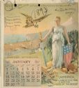
| Date: | 1893 |
|---|---|
| Description: | Calendar front, with the month of January, 1893. At the top it reads: "1893 calendar presented to the farmers of the world with the compliments of Aultman,... |

| Date: | 02 01 1793 |
|---|---|
| Description: | Text in the upper right corner reads, "A Map of The Western Part of the Territories belonging to the United States of America. Drawn from the best authorit... |
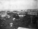
| Date: | 1902 |
|---|---|
| Description: | Elevated view of the city of Port Limon, Costa Rica with the Caribbean Sea in the background. Trees grow amongst the many commercial and residential buildi... |

| Date: | 03 24 1950 |
|---|---|
| Description: | Front cover of a farewell dinner menu from the Italian Line ship Saturnia, with two Commedia dell' Arte characters: Tartaglia, a rotund figure who w... |

| Date: | |
|---|---|
| Description: | Letterhead of Johnson & Melaas, merchant tailors and cloth dealers, "Buyers of wool and Wisconsin leaf tobacco," with an engraving of a waterfront view of ... |
If you didn't find the material you searched for, our Library Reference Staff can help.
Call our reference desk at 608-264-6535 or email us at: