 Filter: Categories of Wisconsin Historical Images
Filter: Subject of Ocean
Filter: Subject of land
Filter: Categories of Wisconsin Historical Images
Filter: Subject of Ocean
Filter: Subject of land
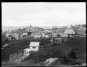
| Date: | 1920 |
|---|---|
| Description: | Elevated view from hill looking down toward buildings in the hills along the coast. |

| Date: | |
|---|---|
| Description: | Etching of the "Attack upon Roanoke Island" by troops landing from naval vessels, after a painting by Chappel. |

| Date: | |
|---|---|
| Description: | Elevated view of village homes on the shores of the bay with docked fishing boats in the foreground. Caption reads, "Marblehead, Mass from Rockmere Point." |

| Date: | |
|---|---|
| Description: | Hand-drawn map of the area at the time of Pilgrim landing, drawn by Charles Blaskowikz. Includes commemorative historical notes. |

| Date: | |
|---|---|
| Description: | Women loading cargo onto a U.S. ship at St. Thomas in the Virgin Islands by way of baskets balanced on the tops of their heads. |
| Date: | |
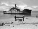
|---|---|
| Description: | View from shoreline toward the wreck of the S.S. Atlantus, a concrete hulled ship in the water near a shoreline. In the foreground are three men on ... |
| Date: | |
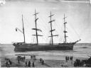
|---|---|
| Description: | A view of the wrecked ship beached in shallow water. The ship ran ashore in 1906. Caption reads: "Wreck of Ship 'Peter Iredale' Clatsop Beach, Ore." |
| Date: | |
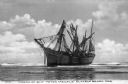
|---|---|
| Description: | Elevated view across beach toward the ship beached in shallow water. There is a crowd of people on the beach in the foreground. Caption reads: "Ship 'Galen... |
| Date: | 1918 |
|---|---|
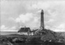
| Description: | View across rocks toward the Mount Desert Rock granite lighthouse, established in 1830 and automated in 1977, located thirty miles out to sea on a treeless... |
| Date: | |
|---|---|
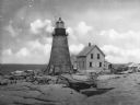
| Description: | View across rocky ground and grass toward the Northern Lighthouse and the nearby cottage. A covered walkway leads from the house up to the entrance of the ... |

| Date: | |
|---|---|
| Description: | Slightly elevated view of a crowd of people standing on boats lined up along a pier to watch a bi-winged airplane flying over the water. Large buildings ar... |
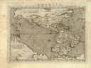
| Date: | 1576 |
|---|---|
| Description: | Map of America. This is the oldest map in the Parker collection. It is based on the geography of Ortelius, who is considered to be the creator of the first... |

| Date: | 1698 |
|---|---|
| Description: | Copperplate engraving. Scale [ca. 1:11,500,00]. |

| Date: | 1744 |
|---|---|
| Description: | Paris: 1744. W 92⁰--W 76⁰/N 49⁰--N 41⁰. Scale [ca. 1:4,000,000] |

| Date: | |
|---|---|
| Description: | View from water of houses along the beach at Dutch Village, each with small outbuildings and umbrellas set up outdoors. A set of stairs leads from the beac... |
| Date: | 1898 |
|---|---|
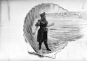
| Description: | A woman in a bathing suit stands on the beach and holds what appears to be a seashell. The ocean is in the background. This woman is contained within a she... |
| Date: | 1910 |
|---|---|
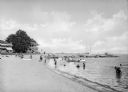
| Description: | Vacationers wade at a beach near a row of what appear to be hotel buildings. Groups of people sit near boats onshore and a group of women sits at the end o... |
| Date: | |
|---|---|
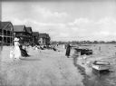
| Description: | View along shoreline toward people relaxing on a beach lined with vacation houses. Groups of men and women are standing or sitting, some wearing street clo... |
| Date: | 1910 |
|---|---|
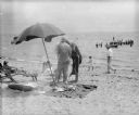
| Description: | A group of sunbathing adults and children standing and sitting near a blanket, folding chairs, and umbrella set up on a beach. In the background, swimmers ... |
If you didn't find the material you searched for, our Library Reference Staff can help.
Call our reference desk at 608-264-6535 or email us at:
