 Filter: Categories of Wisconsin Historical Images
Filter: Subject of Ocean
Filter: Categories of Wisconsin Historical Images
Filter: Subject of Ocean
| Date: | |
|---|---|
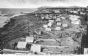
| Description: | Elevated view of an Eskimo tent village on sandspit along the shoreline. Wood buildings are along higher ground on the right near a river. |

| Date: | 1861 |
|---|---|
| Description: | A general map of Pennsylvania, Virginia, New Jersey and Delaware. Insets include maps of New Orleans, Baltimore, St. Louis, Charleston, Savannah, Washingto... |

| Date: | 1865 |
|---|---|
| Description: | This map of Maryland and Virginia shows railroads, rivers, cities and towns, and the positions of Confederate troops and defenses in Virginia in 1861. |
| Date: | |
|---|---|
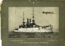
| Description: | Battleship U.S.S. Wisconsin at sea with several men on deck. The mounted photograph was a promotional item for Northwestern National Insurance, Co. |

| Date: | 1860 |
|---|---|
| Description: | This colored map shows railroad lines east of the Mississippi as well as in the states bordering the Mississippi River. The Great Lakes and Gulf of Mexico ... |

| Date: | 1778 |
|---|---|
| Description: | This Italian map from 1778 depicts the upper portion of the Old Northwest. Rivers and lakes are identified and relief, real and imagined, is depicted picto... |

| Date: | 1920 |
|---|---|
| Description: | Templeton (played by Jack Perrin) holds Marama Thurston (Edith Roberts) by the wrist as they stand calf-deep in the surf on the island of Fiji in a scene s... |

| Date: | 1862 |
|---|---|
| Description: | This map of the southeastern United States shows cities and towns, rail lines, and geographic features such as rivers, mountains, lakes, and swamps. |

| Date: | 1862 |
|---|---|
| Description: | This map of the southeastern United States shows forts and battlefields, railroads, rivers, and cities and towns. Dates of admission and secession of the s... |

| Date: | 1863 |
|---|---|
| Description: | A general map of the southeastern United States showing Missouri, Kentucky, West Virginia, Virginia, North Carolina, South Carolina, Georgia, Florida, Alab... |
| Date: | |
|---|---|
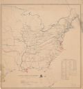
| Description: | Map of the eastern United States that illustrates the limits of the "loyal states" as of July 1861 in red, the territory controlled by United States forces... |
| Date: | |
|---|---|
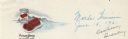
| Description: | Letterhead of the Ocean Spray brand of cranberries, with a can of jellied cranberry sauce and a serving dish with the sauce retaining the shape of its can ... |

| Date: | 1932 |
|---|---|
| Description: | Map of the Middle East accompanying an article on International's involvement in building the Iraq Pipe Line. Headline text on the page reads: "Internation... |

| Date: | 1899 |
|---|---|
| Description: | A map showing the shoreline of a portion of El Montecito, Santa Barbara County, California. The map shows properties along the Pacific Ocean, and may have ... |
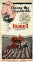
| Date: | 1920 |
|---|---|
| Description: | Front cover of a pamphlet advertising the Huber Light Four tractor, featuring text reading: "Doing the Impossible." Includes an illustration of a farmer dr... |

| Date: | 1952 |
|---|---|
| Description: | Map of the barley-growing regions of North America, published by the Rahr Malting Company, Manitowoc, Wisconsin, 1952. |

| Date: | 1868 |
|---|---|
| Description: | Map showing the northern water routes between Mississippi River and Atlantic Ocean Relief shown by hachures. Includes Profile of the Erie Canal, table of ... |

| Date: | 1625 |
|---|---|
| Description: | An illustrated map of the world with captions in Latin. Illustrations include depictions of the seasons and the elements. |
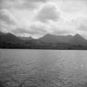
| Date: | 08 11 1943 |
|---|---|
| Description: | A view of Milne Bay, New Guinea (present day Papua New Guinea), from the sea. A ship can be seen on the right, at the shoreline. |
If you didn't find the material you searched for, our Library Reference Staff can help.
Call our reference desk at 608-264-6535 or email us at:
