 Filter: Categories of Wisconsin Historical Images
Filter: Subject of Orchards
Filter: County of Dane
Filter: Creator Name of Unknown
Filter: Categories of Wisconsin Historical Images
Filter: Subject of Orchards
Filter: County of Dane
Filter: Creator Name of Unknown
| Date: | |
|---|---|
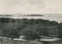
| Description: | Picnic Point from University drive, currently known as Observatory Hill. There are orchards in the foreground. |

| Date: | 1873 |
|---|---|
| Description: | A map of the township of Primrose from the "Atlas of Dane County." |

| Date: | 1873 |
|---|---|
| Description: | A map of the township of Montrose from the "Atlas of Dane County." |
If you didn't find the material you searched for, our Library Reference Staff can help.
Call our reference desk at 608-264-6535 or email us at: