 Filter: Categories of Wisconsin Historical Images
Filter: Subject of Orchards
Filter: County of Dane
Filter: Subject of transportation
Filter: Categories of Wisconsin Historical Images
Filter: Subject of Orchards
Filter: County of Dane
Filter: Subject of transportation
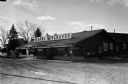
| Date: | 1958 |
|---|---|
| Description: | View of the Kapec Orchards roadside stand from across Verona Road outside Madison. |

| Date: | 1958 |
|---|---|
| Description: | Aerial view of Kapec Orchards on Verona Road between McKee and Nesbitt Roads. |

| Date: | 1873 |
|---|---|
| Description: | A map of the township of Primrose from the "Atlas of Dane County." |

| Date: | 1873 |
|---|---|
| Description: | A map of the township of Montrose from the "Atlas of Dane County." |

| Date: | 1871 |
|---|---|
| Description: | This map shows buildings, roads, the railroad, an orchard, and swamp land. Relief shown by hachures. The map includes an index of buildings in the upper ri... |
If you didn't find the material you searched for, our Library Reference Staff can help.
Call our reference desk at 608-264-6535 or email us at: