 Filter: Categories of Wisconsin Historical Images
Filter: Subject of Peninsulas
Filter: Year of 1900-1999
Filter: Categories of Wisconsin Historical Images
Filter: Subject of Peninsulas
Filter: Year of 1900-1999
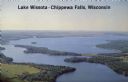
| Date: | 1950 |
|---|---|
| Description: | Color photograph of an aerial view of Lake Wissota looking east on Highway 29. Many resorts are in the area. Lake Wissota is one of the largest man-made la... |
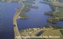
| Date: | 1950 |
|---|---|
| Description: | Aerial view, looking northwest, three miles east of Chippewa Falls, Wisconsin. Big Lake Wissota is seen across from Highway 29 in this color postcard, with... |
| Date: | 04 16 1963 |
|---|---|
| Description: | Chaudoir Dock in Brussels. The shoreline is on the left and has rocks along its edge. In the background is Lake Michigan. |
| Date: | 04 17 1963 |
|---|---|
| Description: | Egg Harbor pier. The shoreline and trees are on the right. There is a cottage area along the shoreline along with a small beach. |

| Date: | 01 06 1958 |
|---|---|
| Description: | Ahnapee & Western Railway Bridge construction. View is from Highway Bridge. There are ships on the right side beyond the bridge. The forested shoreline cur... |

| Date: | 01 06 1958 |
|---|---|
| Description: | Ahnapee & Western Railway Bridge from north side of frozen Sturgeon Bay. The bridge is made of wood (and steel supports???). There is a dock in the foregro... |
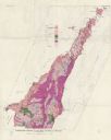
| Date: | 1961 |
|---|---|
| Description: | This map shows bays, lakes, and roads. Relief is shown by contours; depths are shown by isolines. Lake Michigan and Lake Winnebago are labeled. An explana... |

| Date: | 1942 |
|---|---|
| Description: | This pictorial bird's-eye-view map shows the United States of America with parts of Canada and Mexico. Landscape, trade, industry, points of interest, peop... |

| Date: | 1946 |
|---|---|
| Description: | This map shows scenes from America's history with names of historical events superimposed on a map of the United States. |

| Date: | 1990 |
|---|---|
| Description: | This map shows the Minnesota Point, Wisconsin Point, Hog Island, Baker's Island, Connors Point, Blatnik Bridge, Superior Bay, Allouez Bay, the Nemadji Rive... |

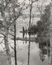
| Date: | 1905 |
|---|---|
| Description: | Campers on Picnic Point. Tents are set up along the shore, under the trees. A few campers are in front of their tents. A canoe is barely visible on the rig... |

| Date: | 09 26 1945 |
|---|---|
| Description: | Elevated view of Peninsula State Park. |

| Date: | 08 20 1951 |
|---|---|
| Description: | Elevated view through trees of the Lake Michigan shoreline. A birch tree with two trunks is in the foreground. |

| Date: | 1915 |
|---|---|
| Description: | View looking down at an Austrian fortress officer lying in the grass at the crest of a ridge line, using it as an observation post while looking for the en... |

| Date: | 1940 |
|---|---|
| Description: | A young woman smiles as she enjoys the view from the Potawatomi Tower in Potawatomi State Park. There is a house on a small island in Sawyer Harbor, with ... |

| Date: | 1968 |
|---|---|
| Description: | Air view of the University of Wisconsin-Madison campus looking north to Lake Mendota. Picnic Point, currently part of the Lakeshore Nature Preserve, and Ca... |

| Date: | 1980 |
|---|---|
| Description: | Aerial shot directly over Picnic Point. Boats are in the lake. Text on reverse reads: "Picnic Point — A peninsula of the University of Wisconsin campus jut... |
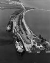
| Date: | 09 17 1948 |
|---|---|
| Description: | Aerial view of two Lake Michigan ferries tied up at harbor slips. The eastern terminus of the Green Bay Route was the Lake Michigan port city of Kewaunee. ... |
| Date: | 1955 |
|---|---|
| Description: | Elevated view towards a woman posing on a spit of land jutting into a lake, seen through birch trees in the spring. Caption reads: "Spring comes suddenly t... |

| Date: | 1916 |
|---|---|
| Description: | Text on front reads: "North Point — Sheboygan, Wis." Elevated view of a Niagara limestone shelf of rock that rises above Lake Michigan. This rarely occurs ... |
If you didn't find the material you searched for, our Library Reference Staff can help.
Call our reference desk at 608-264-6535 or email us at: