 Filter: Categories of Wisconsin Historical Images
Filter: Subject of Peninsulas
Filter: Categories of Wisconsin Historical Images
Filter: Subject of Peninsulas

| Date: | 1942 |
|---|---|
| Description: | This pictorial bird's-eye-view map shows the United States of America with parts of Canada and Mexico. Landscape, trade, industry, points of interest, peop... |

| Date: | 1946 |
|---|---|
| Description: | This map shows scenes from America's history with names of historical events superimposed on a map of the United States. |
| Date: | 1792 |
|---|---|
| Description: | This map depicts the fixed boundaries by a peace treaty between the United States and the Spanish Dominions. |

| Date: | 1990 |
|---|---|
| Description: | This map shows the Minnesota Point, Wisconsin Point, Hog Island, Baker's Island, Connors Point, Blatnik Bridge, Superior Bay, Allouez Bay, the Nemadji Rive... |

| Date: | 2000 |
|---|---|
| Description: | This map shows national parks, county and state forests, Indian reservations, municipal land, private land, docks, boat access, camping, and points of inte... |

| Date: | 1630 |
|---|---|
| Description: | One of the few maps by Dutch cartographer Willem Blaeu depicting the Americas, this map shows regions, settlements, islands, mountains, forests, rivers, an... |

| Date: | 1772 |
|---|---|
| Description: | Map of the north west portion of America and Canada, as well as a small section of eastern Russia. Lakes, rivers, Native American land and the occasional ... |

| Date: | 1905 |
|---|---|
| Description: | Campers on Picnic Point. Tents are set up along the shore, under the trees. A few campers are in front of their tents. A canoe is barely visible on the rig... |

| Date: | 1763 |
|---|---|
| Description: | Map showing the new British territories of East and West Florida following the Treaty of Paris at the end of the French and Indian War. It shows boundaries... |

| Date: | 1765 |
|---|---|
| Description: | Map showing the new British territories of East and West Florida following the Treaty of Paris at the end of the French and Indian War. It shows boundaries... |

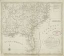
| Date: | 1781 |
|---|---|
| Description: | Map of the Southeastern part of the British Colonies in North America, Gulf Coast and Caribbean. It illustrates the of the Spanish and English fleets, part... |

| Date: | 02 14 2015 |
|---|---|
| Description: | View of a corner of the Limnology Center on the shoreline of Lake Mendota. The building overhang is shading a walkway along the shore. A memorial stone and... |

| Date: | 09 26 1945 |
|---|---|
| Description: | Elevated view of Peninsula State Park. |

| Date: | 08 20 1951 |
|---|---|
| Description: | Elevated view through trees of the Lake Michigan shoreline. A birch tree with two trunks is in the foreground. |

| Date: | |
|---|---|
| Description: | Elevated view of the park and the Lake Michigan shoreline. Description on the photograph record reads: "Looking Northeast from Sven's Tower." |

| Date: | 1915 |
|---|---|
| Description: | View looking down at an Austrian fortress officer lying in the grass at the crest of a ridge line, using it as an observation post while looking for the en... |

| Date: | 1940 |
|---|---|
| Description: | A young woman smiles as she enjoys the view from the Potawatomi Tower in Potawatomi State Park. There is a house on a small island in Sawyer Harbor, with ... |

| Date: | 1968 |
|---|---|
| Description: | Air view of the University of Wisconsin-Madison campus looking north to Lake Mendota. Picnic Point, currently part of the Lakeshore Nature Preserve, and Ca... |

| Date: | 1980 |
|---|---|
| Description: | Aerial shot directly over Picnic Point. Boats are in the lake. Text on reverse reads: "Picnic Point — A peninsula of the University of Wisconsin campus jut... |

| Date: | |
|---|---|
| Description: | View of Picnic Point from Observatory Hill on the University of Wisconsin campus. Autumn color is in the trees. |
If you didn't find the material you searched for, our Library Reference Staff can help.
Call our reference desk at 608-264-6535 or email us at: