 Filter: Categories of Wisconsin Historical Images
Filter: Subject of Plantations
Filter: Subject of human settlements
Filter: Categories of Wisconsin Historical Images
Filter: Subject of Plantations
Filter: Subject of human settlements
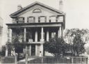
| Date: | 1887 |
|---|---|
| Description: | Built in 1840 by Lemuel Hull. William Singer was the mason. The basement was made by lowering the hill. There were originally only two stories. First ... |

| Date: | 1949 |
|---|---|
| Description: | Manager's house on an International Harvester sisal plantation in Cuba. Original caption reads: "View of the manager's home on the IH plantation in Cuba. T... |

| Date: | 1949 |
|---|---|
| Description: | An exterior view of the homes provided for management at International Harvester's sisal plantation in Cuba. |

| Date: | 1949 |
|---|---|
| Description: | View of a worker's village on an International Harvester sisal plantation in Cuba. Caption on photograph reads, "View of typical worker's village. This vil... |

| Date: | 1949 |
|---|---|
| Description: | An exterior view of the housing for workers on an International Harvester sisal plantation in Cuba. A man is sitting on the porch in the distance. Caption ... |

| Date: | 1949 |
|---|---|
| Description: | A long building containing workers quarters at an International Harvester sisal plantation in Cuba. The homes all share a long, covered porch. The lawns ar... |

| Date: | 1900 |
|---|---|
| Description: | View of a group of three women and seven children sitting on the porch of a log cabin. The caption at top right corner reads: "On The Plantation." |

| Date: | 1780 |
|---|---|
| Description: | This map shows the townships, parishes, cities, towns, plantations, lakes, rivers, swamps, and roads near the coast of South Carolina and Georgia. Emphasis... |

| Date: | 1776 |
|---|---|
| Description: | Map of Virginia and parts of Maryland and Delaware (written "De La War"). It shows borders, counties, cities, towns, plantations (marked by landowners name... |
If you didn't find the material you searched for, our Library Reference Staff can help.
Call our reference desk at 608-264-6535 or email us at: