 Filter: Categories of Wisconsin Historical Images
Filter: Subject of Plantations
Filter: Subject of land
Filter: Categories of Wisconsin Historical Images
Filter: Subject of Plantations
Filter: Subject of land

| Date: | 06 1948 |
|---|---|
| Description: | Ranger Jack Zimmerman in 10-year-old Red Pine Plantation near Blackwell in Nicolet National Forest. |
| Date: | |
|---|---|
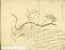
| Description: | Drawn map of Blackstock's Plantation battlefield from the Sumter Papers. |
| Date: | |
|---|---|
| Description: | Drawn map of Blackstock's Plantation battlefield from the Thomas Sumter Papers. |
| Date: | |
|---|---|
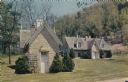
| Description: | Color postcard of the Old Smokehouse at Stonefield Village. The old wine cellar is also pictured. |

| Date: | 1785 |
|---|---|
| Description: | Map of part of North America engraved and hand-colored (the light brown design is a superposition of the map and cartouche derived from the oxidation of th... |

| Date: | 1942 |
|---|---|
| Description: | Three-quarter view from front left of a woman on a Farmall H tractor in a field. Caption: "A very successful tractorette class of twenty women was organize... |

| Date: | 1942 |
|---|---|
| Description: | Three-quarter view from front left of a woman on a Farmall H tractor in a field. Caption on accompany photograph: "A very successful tractorette class of t... |

| Date: | 05 21 1936 |
|---|---|
| Description: | Rear view of man driving a Farmall tractor in a field. Used by the Kiluea Plantation, Island of Kauai. It is called an Australia Spinner, mounted on a Farm... |

| Date: | 1780 |
|---|---|
| Description: | This map shows the townships, parishes, cities, towns, plantations, lakes, rivers, swamps, and roads near the coast of South Carolina and Georgia. Emphasis... |

| Date: | 1776 |
|---|---|
| Description: | Map of Virginia and parts of Maryland and Delaware (written "De La War"). It shows borders, counties, cities, towns, plantations (marked by landowners name... |
If you didn't find the material you searched for, our Library Reference Staff can help.
Call our reference desk at 608-264-6535 or email us at: