 Filter: Categories of Wisconsin Historical Images
Filter: Subject of Plantations
Filter: Subject of trees
Filter: Categories of Wisconsin Historical Images
Filter: Subject of Plantations
Filter: Subject of trees
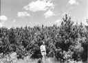
| Date: | 06 1948 |
|---|---|
| Description: | Ranger Jack Zimmerman in 10-year-old Red Pine Plantation near Blackwell in Nicolet National Forest. |
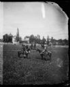
| Date: | 1877 |
|---|---|
| Description: | H.A. Prensor and J.A. Ottesen and their families leaving the home of R. Daniel Rickelsen in Lodi. |
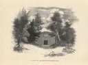
| Date: | 1835 |
|---|---|
| Description: | Engraving entitled "Tomb of Washington--Mount Vernon". |
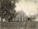
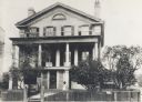
| Date: | 1902 |
|---|---|
| Description: | Several individuals pose in front of the residence of C.A. Lowry. The original caption reads: "Mr. Lowry bought 9,000 acres fronting on the Mermentau River... |
| Date: | 1942 |
|---|---|
| Description: | Piles of cotton fill a storage bin at the Hopson Planting Company plantation. |
| Date: | 1887 |
|---|---|
| Description: | Built in 1840 by Lemuel Hull. William Singer was the mason. The basement was made by lowering the hill. There were originally only two stories. First ... |

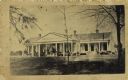
| Date: | 1949 |
|---|---|
| Description: | A man mows the front lawn of a manager's home on an International Harvester sisal plantation in Cuba. The house belonged to "Mr. Heath." |

| Date: | |
|---|---|
| Description: | The Hermitage was purchased by Andrew Jackson on July 5, 1804. The grounds included the mansion as well as a 1,000-acre plantation. |
| Date: | |
|---|---|
| Description: | Exterior view of Brierfield, a plantation bought by Jefferson Davis in 1835, after he fought in the Mexican War. After the Civil War he bought Beauvoir, a ... |
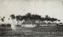
| Date: | 1913 |
|---|---|
| Description: | Rows of shacks, possibly company housing, identical in style and size, including thatched roofing. The shacks are likely part of a henequen or sisal planta... |
| Date: | |
|---|---|
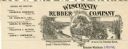
| Description: | Letterhead of the Wisconsin Rubber Company of Madison, Wisconsin, which operated the Florida plantation in the state of Chiapas, Mexico. Includes an oval i... |

| Date: | 1920 |
|---|---|
| Description: | Front cover of a brochure advertising the oversize model 20-35 Yuba tractor. The cover features an illustration of a tractor parked in front of a large hou... |
| Date: | |
|---|---|
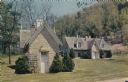
| Description: | Color postcard of the Old Smokehouse at Stonefield Village. The old wine cellar is also pictured. |
| Date: | |
|---|---|
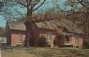
| Description: | Color postcard view of Nelson Dewey's house at Stonefield Village. |

| Date: | 1785 |
|---|---|
| Description: | Map of part of North America engraved and hand-colored (the light brown design is a superposition of the map and cartouche derived from the oxidation of th... |

| Date: | 1942 |
|---|---|
| Description: | Three-quarter view from front left of a woman on a Farmall H tractor in a field. Caption: "A very successful tractorette class of twenty women was organize... |

| Date: | 1942 |
|---|---|
| Description: | Three-quarter view from front left of a woman on a Farmall H tractor in a field. Caption on accompany photograph: "A very successful tractorette class of t... |
| Date: | 1900 |
|---|---|
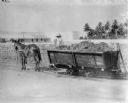
| Description: | Man on horse-drawn cart, on railroad tracks. The cart is filled with harvested manila. Long, low buildings are in the background on the left behind a fence... |
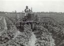
| Date: | 1939 |
|---|---|
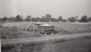
| Description: | View from front of a man driving a Farmall M tractor with a 4 row cultivator in a field near Greenwood on the D.D. Weir plantation. There are small buildin... |

| Date: | 1780 |
|---|---|
| Description: | This map shows the townships, parishes, cities, towns, plantations, lakes, rivers, swamps, and roads near the coast of South Carolina and Georgia. Emphasis... |
If you didn't find the material you searched for, our Library Reference Staff can help.
Call our reference desk at 608-264-6535 or email us at: