Filter: Categories of Wisconsin Historical Images
Filter: Subject of Plaques, plaquettes
Filter: Year of 1900-1999
Filter: Year of 1930-1939
Filter: Subject of land use
Filter: Categories of Wisconsin Historical Images
Filter: Subject of Plaques, plaquettes
Filter: Year of 1900-1999
Filter: Year of 1930-1939
Filter: Subject of land use
| Date: | 1931 |
|---|---|
| Description: | View of the Radisson-Groseilliers house historic site marker in the vicinity of Ashland. The marker was unveiled at the mouth of Fish Creek on October 25, ... |
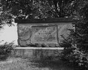
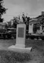
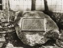
| Date: | 1935 |
|---|---|
| Description: | Close-up of the Radisson and Groseilliers house historic site marker, commemorating the first house built in Wisconsin by white men. The house was believed... |
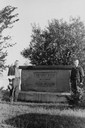
| Date: | 1936 |
|---|---|
| Description: | View of two men posing on either side of the Radisson and Groseilliers House historical marker. The house was the first built by white men in Wisconsin and... |
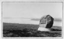
| Date: | 1930 |
|---|---|
| Description: | Inscription of Brule River monument. Placed where the Brule River is crossed by the Memorial Highway from Superior to Brule and Ashland (Highway 2). |
| Date: | 1930 |
|---|---|
| Description: | Historical marker on the site of Henry Dodge's homestead. Dodge was the first territorial governor of Wisconsin. |
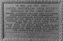
| Date: | 1935 |
|---|---|
| Description: | Close-up view of the Big Foot village marker erected by the Geneva Lake Historical Society. The plaque reads: "A village of Potawatomi Indians occupied the... |
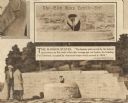
| Date: | 1930 |
|---|---|
| Description: | View of the panther itaglio effigy mound marker, located on Highway 106 West. The text on the marker reads: "Panther Intaglio Effigy; Panther Type, Length ... |

| Date: | 1936 |
|---|---|
| Description: | View of the panther intaglio effigy mound marker, located on Highway 106 West. The text on the marker reads: "Indian Intaglio Effigy; Panther Type, Length ... |
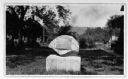
| Date: | 1933 |
|---|---|
| Description: | Two people stand in front of the Ella Hoes Neville well and historic marker, with two insets with close-up views of its architecture. |
| Date: | 1930 |
|---|---|
| Description: | View of an Indian mounds marker on the St. Croix River. |

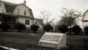
| Date: | 1930 |
|---|---|
| Description: | The Bond historical site marker, marking the home where Carrie Jacobs Bond wrote "I Love You Truly." |
| Date: | 1936 |
|---|---|
| Description: | A monument marking the Treaty of the Cedars. |
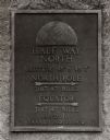
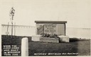
| Date: | 1938 |
|---|---|
| Description: | The 45th parallel of north latitude marker, marking halfway between the equator and the north pole. The marker is located on Highway 141, three miles north... |
| Date: | 1930 |
|---|---|
| Description: | A linear burial mound and historic marker at the University Ridge mound group on the University of Wisconsin-Madison campus. The mound group was eventually... |

| Date: | 05 05 1939 |
|---|---|
| Description: | Charles E. Brown poses near a historic tablet marking one of a row of conical burial mounds on the Park and Pleasure drive on the north shore of Lake Wingr... |
| Date: | 1930 |
|---|---|
| Description: | An Indian trail marker erected "in honor of our pioneers". This trail later became the Plank Road between Sheboygan and Fond du Lac, Wisconsin. The first h... |
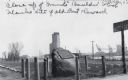
| Date: | 1930 |
|---|---|
| Description: | Historic marker placed on the site of the first cabin built in Milwaukee, 1795. A replica cabin is behind. The plaque says: On this site the first permane... |
If you didn't find the material you searched for, our Library Reference Staff can help.
Call our reference desk at 608-264-6535 or email us at: