 Filter: Categories of Wisconsin Historical Images
Filter: Subject of Ponds
Filter: Creator Name of Unknown
Filter: Subject of land use, rural
Filter: Categories of Wisconsin Historical Images
Filter: Subject of Ponds
Filter: Creator Name of Unknown
Filter: Subject of land use, rural
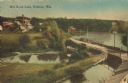
| Date: | 1905 |
|---|---|
| Description: | Elevated view of a pond, a stream, and a lake, with a road dividing the pond and stream from the lake. Industrial buildings and a smokestack are in the bac... |
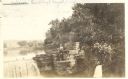
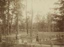
| Date: | 1915 |
|---|---|
| Description: | View of several people posing near the pond and spillway on the grounds of Taliesin, Frank Lloyd Wright's residence and architectural school complex. Talie... |
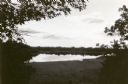
| Date: | 1923 |
|---|---|
| Description: | View of Fountain Lake (officially known as Ennis Lake), John Muir's boyhood home near Montello. The area is now a 125-acre State Natural Area. Fountain Lak... |
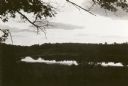
| Date: | 1923 |
|---|---|
| Description: | View of Fountain Lake (officially known as Ennis Lake), John Muir's boyhood home near Montello. The area is now a 125-acre State Natural Area. Fountain Lak... |
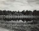
| Date: | 1948 |
|---|---|
| Description: | Bee hives near the Bennett cranberry marshes. |
| Date: | 1888 |
|---|---|
| Description: | Several adults, two children and a dog enjoying a pond at Bracken Brae, the country home of John Johnston (1836-1904), a successful Milwaukee banker. Hilda... |
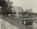
| Date: | 09 09 1922 |
|---|---|
| Description: | The farmhouse of the Wetherby Cranberry Company. At the time the farmhouse was owned by H. Kissinger. In the foreground is the corner of the water reservoi... |

| Date: | 1932 |
|---|---|
| Description: | View from shoreline of a pond that has formed behind a beaver dam. |

| Date: | |
|---|---|
| Description: | A laughing young man and woman sitting on a stile. The man is wearing a straw hat and bow tie; she is wearing a striped dress and matching jacket. The woma... |

| Date: | 06 30 1895 |
|---|---|
| Description: | A man is standing in the right foreground near a tall plant, perhaps corn. In the center is a square-shaped pond with high banks. A man is in the backgroun... |

| Date: | 1776 |
|---|---|
| Description: | Fairly detailed map of New York City and parts of Long Island. It shows streets, roads, wharves, ferries, ship yards, Fort George and the battery, public b... |
If you didn't find the material you searched for, our Library Reference Staff can help.
Call our reference desk at 608-264-6535 or email us at: