 Filter: Categories of Wisconsin Historical Images
Filter: Subject of Ponds
Filter: Creator Name of Unknown
Filter: Year of 1800-1899
Filter: Categories of Wisconsin Historical Images
Filter: Subject of Ponds
Filter: Creator Name of Unknown
Filter: Year of 1800-1899

| Date: | 1874 |
|---|---|
| Description: | Bird's-eye map of Chippewa Falls. |
| Date: | 1880 |
|---|---|
| Description: | View across water towards the Hull mill (right), showing Merlin Hull's ancestral home at left. |

| Date: | 1875 |
|---|---|
| Description: | An artist's depiction of an elevated view of the first State Fish Hatchery (aka Nevin Fish Hatchery, 3911 Fish Hatchery Road). |
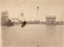
| Date: | 1898 |
|---|---|
| Description: | Elevated view of a mill pond, with a group of three women and a man standing near the shoreline on the right. |

| Date: | 1825 |
|---|---|
| Description: | Portion of a map showing a survey of Lake Superior including the River St. Louis. |
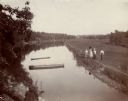
| Date: | 1870 |
|---|---|
| Description: | Two men are in the foreground on a shoreline, one standing in a boat. In the background on the other shoreline are adults and children sitting in the gras... |

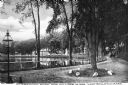
| Date: | 1870 |
|---|---|
| Description: | View toward the tombstones and a building at Hillside Cemetery and Park. In the foreground is a pond surrounded by vegetation. |
| Date: | 1899 |
|---|---|
| Description: | A man steers a horse and carriage down a winding country road near Clarendon Pond. Village dwellings are visible across the pond. |
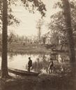
| Date: | 1888 |
|---|---|
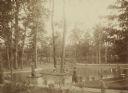
| Description: | Several adults, two children and a dog enjoying a pond at Bracken Brae, the country home of John Johnston (1836-1904), a successful Milwaukee banker. Hilda... |
| Date: | 1890 |
|---|---|
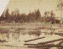
| Description: | 90,000 feet of pine logs floating in the storage/sorting pond at the Arpin Lumber Company sawmill. The sawmill and other buildings are in the background. O... |

| Date: | 1873 |
|---|---|
| Description: | A map of the township of Montrose from the "Atlas of Dane County." |

| Date: | 1896 |
|---|---|
| Description: | This map shows plat of town, local streets, numbered blocks and lots, mill pond, mills, part of the Red Cedar River, and land and property ownership by nam... |

| Date: | 06 30 1895 |
|---|---|
| Description: | A man is standing in the right foreground near a tall plant, perhaps corn. In the center is a square-shaped pond with high banks. A man is in the backgroun... |

| Date: | 1857 |
|---|---|
| Description: | Green Lake County abstract plat map, T. 17 N, R. 11 E. |
If you didn't find the material you searched for, our Library Reference Staff can help.
Call our reference desk at 608-264-6535 or email us at: