 Filter: Categories of Wisconsin Historical Images
Filter: Subject of Postal service
Filter: Year of 1800-1899
Filter: Subject of economics
Filter: Categories of Wisconsin Historical Images
Filter: Subject of Postal service
Filter: Year of 1800-1899
Filter: Subject of economics
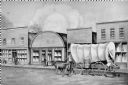
| Date: | 1858 |
|---|---|
| Description: | View on North Water Street, showing the building in which the Bank of Sparta was founded. A man is walking beside a oxen pulling a covered wagon. |

| Date: | 1898 |
|---|---|
| Description: | Shows railway lines in Wisconsin marked in red and counties in colors. The meridians are Greenwich, Wisconsin and Washington, Wisconsin. The map folds into... |
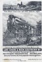
| Date: | 1876 |
|---|---|
| Description: | Railroad advertising card showing a mail carrier on horseback on a plank road in 1776, and mail being delivered by train in 1876. A woman with two children... |

| Date: | 1879 |
|---|---|
| Description: | A map of Jackson County, Wisconsin, shows the township and section survey, landownership, towns, villages, buildings, roads, railroads, county land, and st... |

| Date: | 1877 |
|---|---|
| Description: | This 1877 map of Trempealeau County, Wisconsin, shows the township and range grid, sections, towns, cities and villages, land ownership and acreages, roads... |

| Date: | 1878 |
|---|---|
| Description: | This 1878 map of Vernon County, Wisconsin, shows the township and range grid, sections, towns, cities and villages, land ownership and acreages, roads, rai... |

| Date: | 1896 |
|---|---|
| Description: | This late 19th-century map of Dodge County, Wisconsin, shows the township and range grid, towns, sections, cities, villages and post offices, some property... |

| Date: | 09 1893 |
|---|---|
| Description: | Shows townships and sections, landownership and acreages, buildings, and school districts. Includes vignettes of local buildings, business directory, list ... |

| Date: | 1876 |
|---|---|
| Description: | Map shows townships and sections, landownership and acreages, roads, railroads, post offices, and farms. Sections appear in pink, yellow, and blue. On the ... |
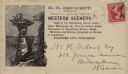
| Date: | 1891 |
|---|---|
| Description: | H.H. Bennett advertising envelope addressed to William H. Metcalf of Milwaukee. The envelope bears an engraved image of people standing on top of Stand Roc... |

| Date: | 1860 |
|---|---|
| Description: | This map shows roads, trails, and railroads throughout Nebraska, Arkansas, Missouri, Kansas, Illinois, and Utah, including the Salt Lake City & California ... |
If you didn't find the material you searched for, our Library Reference Staff can help.
Call our reference desk at 608-264-6535 or email us at: