 Filter: Categories of Wisconsin Historical Images
Filter: Subject of Postal service
Filter: Year of 1800-1899
Filter: Subject of transportation
Filter: Subject of cities and towns
Filter: Categories of Wisconsin Historical Images
Filter: Subject of Postal service
Filter: Year of 1800-1899
Filter: Subject of transportation
Filter: Subject of cities and towns
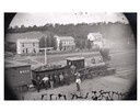
| Date: | 1873 |
|---|---|
| Description: | Elevated view of several men, some of whom may be railroad workers, posing in front of a Minnesota and St. Paul wood-burning engine at a train crossing. Th... |

| Date: | 03 1876 |
|---|---|
| Description: | Side view of the locomotive purchased by the Pine River and Stevens Point Railroad, being hauled over land from Lone Rock to Richland Center. In the backgr... |

| Date: | 1876 |
|---|---|
| Description: | "View of the Capitol, with all the Flags" one of four "Different Views of Parades in the Streets" identified in Dahl's 1877 "Catalogue of Stereoscopic View... |

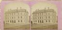
| Date: | 1875 |
|---|---|
| Description: | The City of Madison, Federal Post Office, at the corner of Wisconsin and Mifflin Streets. The cornerstone was laid on May 27, 1869. The building was demoli... |
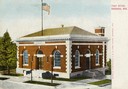
| Date: | 1895 |
|---|---|
| Description: | Elevated view across street towards the post office. Caption reads: "Post Office, Baraboo, Wis." |
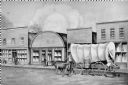
| Date: | 1858 |
|---|---|
| Description: | View on North Water Street, showing the building in which the Bank of Sparta was founded. A man is walking beside a oxen pulling a covered wagon. |

| Date: | 1868 |
|---|---|
| Description: | Elevated view up Wisconsin Avenue showing City Hall on the corner at Mifflin Street on the left, with the Post Office to the right. Further down is the Pre... |

| Date: | 1898 |
|---|---|
| Description: | Shows railway lines in Wisconsin marked in red and counties in colors. The meridians are Greenwich, Wisconsin and Washington, Wisconsin. The map folds into... |
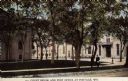
| Date: | 1890 |
|---|---|
| Description: | View across street towards the Columbia County Court House and Post Office. Caption reads: "Court House and Post Office at Portage, Wis." |
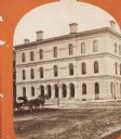
| Date: | 1880 |
|---|---|
| Description: | Stereograph of the old Post Office that was located at the corner of Wisconsin Avenue and Mifflin Street. |

| Date: | 1890 |
|---|---|
| Description: | A view looking down Wisconsin Avenue as seen from the Wisconsin State Capitol grounds. On the right, the post office is visible. |
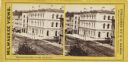
| Date: | 1880 |
|---|---|
| Description: | Stereograph. Elevated view of corner of Milwaukee and Wisconsin Streets. Three-story white building with several chimneys. A horse and cart are on the rig... |
| Date: | 1876 |
|---|---|
| Description: | Stereograph. Building also housed the Custom House. Corner of Milwaukee and Wisconisn Streets. |
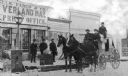
| Date: | 1890 |
|---|---|
| Description: | Men with a stagecoach in front of the Wells Fargo Mail and Express Company. In 1858, Wells Fargo helped start the Overland Mail Company, also known as the ... |

| Date: | 1870 |
|---|---|
| Description: | Stereograph looking south from the post office at the corner of Mifflin Street and Wisconsin Avenue across one corner of the Capitol Square toward Grace Ep... |

| Date: | 1853 |
|---|---|
| Description: | Wisconsin counties by color and shows railroads, common roads, canals, the state capital, county towns, townships, villages, and post offices, |

| Date: | 1854 |
|---|---|
| Description: | Map of the whole state Wisconsin includes an inset of the vicinity of Milwaukee, which shows the boundaries for Lisbon, Menomonee, Pewaukee, Brookfield, Wa... |

| Date: | 1856 |
|---|---|
| Description: | A hand-colored map of Wisconsin, showing the county boundaries, towns, cities, railroads, roads, lakes, rivers, bays, and the Lake Superior’s islands. In ... |

| Date: | 1892 |
|---|---|
| Description: | This map oriented with north to the upper left shows railroads, creeks, post offices, smaller lakes, Lake Mendota, Lake Monona, Lake Wingra, Lake Waubesa, ... |

| Date: | 1862 |
|---|---|
| Description: | This map of eastern Virginia and Maryland shows rivers, roads and railroads from Hagerstown, Maryland, south to Suffolk, Virginia, and west to Staunton, Vi... |
If you didn't find the material you searched for, our Library Reference Staff can help.
Call our reference desk at 608-264-6535 or email us at: