 Filter: Categories of Wisconsin Historical Images
Filter: Subject of Postal service
Filter: Year of 1800-1899
Filter: Year of 1870-1879
Filter: Creator Name of Unknown
Filter: Categories of Wisconsin Historical Images
Filter: Subject of Postal service
Filter: Year of 1800-1899
Filter: Year of 1870-1879
Filter: Creator Name of Unknown
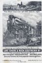
| Date: | 1876 |
|---|---|
| Description: | Railroad advertising card showing a mail carrier on horseback on a plank road in 1776, and mail being delivered by train in 1876. A woman with two children... |

| Date: | 1873 |
|---|---|
| Description: | Engraved image of a lock and dam at Sault St. Marie. Two men are operating the sluice as ships are waiting on the opposite side of the lock. Another man is... |

| Date: | 1876 |
|---|---|
| Description: | Map shows townships and sections, landownership and acreages, roads, railroads, post offices, and farms. Sections appear in pink, yellow, and blue. On the ... |

| Date: | 1871 |
|---|---|
| Description: | Map created between 1871 and 1880. Shows townships, post offices, a possible railroad to Penoka Iron Range, and the North Wisconsin Railroad. |

| Date: | 1878 |
|---|---|
| Description: | This bird’s-eye-view map of Barton is indexed for parochial and public schools, churches, a convent, the railroad depot, and the post office. |

| Date: | 1874 |
|---|---|
| Description: | This map shows townships and sections, post offices, roads, and railroads. The left margin reads: "For sale at Cushing Land Agency, St. Croix Falls, Wis. 4... |
If you didn't find the material you searched for, our Library Reference Staff can help.
Call our reference desk at 608-264-6535 or email us at: