 Filter: Categories of Wisconsin Historical Images
Filter: Subject of Railroad stations
Filter: Subject of aerial photographs
Filter: Categories of Wisconsin Historical Images
Filter: Subject of Railroad stations
Filter: Subject of aerial photographs

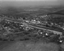
| Date: | 1956 |
|---|---|
| Description: | Aerial view of the Chicago, Milwaukee, and St. Paul Railroad station, roundhouse, and yard at the intersection of West Washington Avenue (across lower left... |

| Date: | |
|---|---|
| Description: | An aerial view of downtown, including a baseball field in the lower left near a train station. |
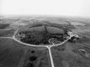
| Date: | 04 30 1949 |
|---|---|
| Description: | Aerial photograph of Barneveld, Wisconsin. |

| Date: | |
|---|---|
| Description: | An aerial view of the port and a section of the city showing a large boat, a railway depot, a park plaza and a grid of city streets with large buildings. |
| Date: | 09 1996 |
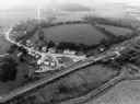
|---|---|
| Description: | "As you look north, North Pole Road intersects DD. At the right is Theresa Station." |
| Date: | 09 1996 |
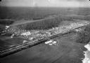
|---|---|
| Description: | "This is Theresa Station. Note the Rock River and Soo Line Railroad track." |
| Date: | 06 1935 |
|---|---|
| Description: | Aerial view of. Original caption on AP print reads: "Matanuska Valley, Alaska, Sept. 15--Twentieth Century Pioneers--Breaking a wilderness to the purposes ... |
If you didn't find the material you searched for, our Library Reference Staff can help.
Call our reference desk at 608-264-6535 or email us at: