 Filter: Categories of Wisconsin Historical Images
Filter: Subject of Railroad stations
Filter: Subject of lakes
Filter: Categories of Wisconsin Historical Images
Filter: Subject of Railroad stations
Filter: Subject of lakes

| Date: | 11 12 1936 |
|---|---|
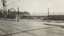
| Description: | Chicago & Northwestern Railroad tracks, looking west at the crossing of S. Blair Street, King Street, E. Wilson Street, and Williamson Street. Shows Chicag... |
| Date: | |
|---|---|
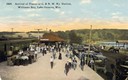
| Description: | Elevated view of passengers arriving on the Chicago & Northwestern Railroad train at the Williams Bay station. Many automobiles are parked near the depot, ... |

| Date: | |
|---|---|
| Description: | Map of the City of the First Lake. Drawn by J. Judson, Greene & McGowran litho. Scale: 200 ft. to 1 inch. "Paper city located near Lake Kegonsa." |

| Date: | 1905 |
|---|---|
| Description: | Clockwise from upper left images include: Cutters Point, Long Lake, Wis.; M.E. Church, New Auburn, Wis.; Farmers Store, New Auburn, Wis.; Public School, Ne... |
| Date: | 08 06 1917 |
|---|---|
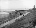
| Description: | Overlooking the Chicago and North Western railroad depot from Juneau Park bluff. Caption on glass plate reads: "Extention [sic] of Juneau Park, show... |
| Date: | 1915 |
|---|---|
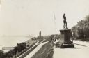
| Description: | Located in Juneau Park, the statue is on the right, on the edge of a steep hill. The hillside is lined with paths, and ends next to several railroad track... |
| Date: | 1893 |
|---|---|
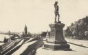
| Description: | Statue of Leif Ericson is to the right of center in the foreground, with the figure facing the city. On the left is a hill with paths, a train station, ra... |
| Date: | 1918 |
|---|---|
| Description: | The East Madison Chicago, Milwaukee, and St. Paul railroad station, 501 East Wilson Street, from South Hancock Street, with Lake Monona in the background. ... |

| Date: | 1918 |
|---|---|
| Description: | A view looking east along East Wilson Street with the Chicago, Milwaukee, and St. Paul East Madison railroad station, 501 East Wilson Street, on the right.... |

| Date: | 1896 |
|---|---|
| Description: | A map of the Chain-O-Lakes in Waupaca, including Indian trails. The path of the Waupaca Electric Railway from the Grand View Hotel to the Wisconsin Central... |

| Date: | 1930 |
|---|---|
| Description: | Pictorial map of Glacier National Park, Montana and Waterton Lakes National Park, Alberta. Illustrated by Joe Scheurle, it depicts white people, American ... |

| Date: | 1866 |
|---|---|
| Description: | This map shows the railroads both completed and under construction in southern Wisconsin, Iowa, Illinois, and Missouri. Railroad terminals, junctions, and ... |

| Date: | 1867 |
|---|---|
| Description: | This map, which includes eastern Iowa, northern Illinois and the western portion of Michigan's Upper peninsula, shows the township survey grid and identifi... |

| Date: | |
|---|---|
| Description: | A map that shows the Wisconsin Central Railway land grant lands for sale by the Soo Line, the Chicago, Milwaukee, and St. Paul Railway. Town sections, lak... |

| Date: | 1858 |
|---|---|
| Description: | An ink on paper map of Milwaukee County and the eastern portion of Waukesha County that shows the townships of Oak Creek, Franklin, Greenfield, Wauwatosa, ... |

| Date: | 1886 |
|---|---|
| Description: | A hand-colored map of Milwaukee County, Wisconsin that shows the township and range system, sections, towns, roads, railroads and rail stations, cities and... |

| Date: | 1891 |
|---|---|
| Description: | A hand-colored map of Milwaukee County, Wisconsin that shows the township and range system, sections, towns, roads, railroads and rail stations, cities and... |

| Date: | 1898 |
|---|---|
| Description: | Map showing the contour depths of the lakes in northwestern Waukesha County, Wisconsin. Roads, railroads, depots, churches, schools, and hotels in the area... |

| Date: | 1896 |
|---|---|
| Description: | This 1896 map of Douglas County, Wisconsin, shows the township and range grid, the towns of Superior, Brule, Gordon, and Nebagamain, sections, cities and v... |

| Date: | 1914 |
|---|---|
| Description: | Includes index of University of Wisconsin buildings, churches, and public buildings. Top of Map reads: '"GET A SQUARE DEAL" AT THE COLLEGE BOOK STORE SHOWN... |
If you didn't find the material you searched for, our Library Reference Staff can help.
Call our reference desk at 608-264-6535 or email us at: