 Filter: Categories of Wisconsin Historical Images
Filter: Subject of Railroad stations
Filter: Subject of lumber trade
Filter: Categories of Wisconsin Historical Images
Filter: Subject of Railroad stations
Filter: Subject of lumber trade
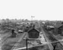
| Date: | 1909 |
|---|---|
| Description: | Elevated view of the Fennimore, primarily the train depot. There is a windmill near railroad cars, and dwellings are in the distance. |
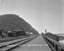
| Date: | 1909 |
|---|---|
| Description: | View along a brick platform towards the Glen Haven depot, where two men stand against the building. Behind the depot is a building with a sign for the "Me... |

| Date: | 12 1912 |
|---|---|
| Description: | Sanborn Map of Sun Prairie. The map highlights the public and parochial schools, the exhange, and church buildings, etc. |

| Date: | 1892 |
|---|---|
| Description: | A Sanborn map of St. Louis, which is six miles southwest of South Superior. |

| Date: | 10 1894 |
|---|---|
| Description: | A Sanborn Fire Insurance Map of Waunakee. |
If you didn't find the material you searched for, our Library Reference Staff can help.
Call our reference desk at 608-264-6535 or email us at: