 Filter: Categories of Wisconsin Historical Images
Filter: Subject of Railroad stations
Filter: Subject of michigan, lake
Filter: Categories of Wisconsin Historical Images
Filter: Subject of Railroad stations
Filter: Subject of michigan, lake
| Date: | |
|---|---|
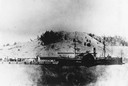
| Description: | The sidewheel passenger and freight, "Milwaukee," at Dewey Hill, Grand Haven, Michigan, at the Detroit, Grand Haven and Milwaukee Railway depot. |
| Date: | 1865 |
|---|---|
| Description: | Elevated view of the first Milwaukee railroad depot, which was used by the Milwaukee & Waukesha and the Milwaukee & Mississippi railroads. The Milwaukee &... |
| Date: | 08 06 1917 |
|---|---|
| Description: | Chicago and North Western Railrod depot at the east end of Wisconsin Avenue. Caption on glass plate reads: "South end of Juneau Park extention [sic]... |
| Date: | 08 06 1917 |
|---|---|
| Description: | Overlooking the Chicago and North Western railroad depot from Juneau Park bluff. Caption on glass plate reads: "Extention [sic] of Juneau Park, show... |
| Date: | 1895 |
|---|---|
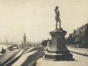
| Description: | Side view of the statue on a plinth with Celtic designs, with his right hand holding a horn resting on his hip. The statue is located in Juneau Park. On th... |
| Date: | |
|---|---|
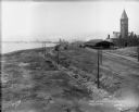
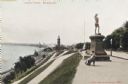
| Description: | Train station in the distance, with a man standing in the foreground on steps leading down to the lake, near a fenced-in pond. On the left are railroad tra... |
| Date: | 1910 |
|---|---|
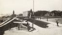
| Description: | A canon is in the foreground to the left. There are a number of pedestrians in the park and on the path by the lake. In the background on the left is a tra... |
| Date: | 1910 |
|---|---|
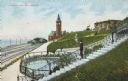
| Description: | View along top of hill in the park toward a woman and child sitting on a bench near the monument. At the bottom of the hill on the left are railroad tracks... |
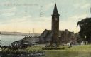
| Date: | 1910 |
|---|---|
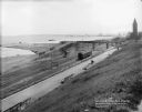
| Description: | Chicago & Northwestern Railway Depot, with train shed and clock tower. In the foreground is a landscaped area with flowers. In the background is Lake Mich... |
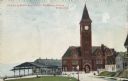
| Date: | 1904 |
|---|---|
| Description: | The station with the clock tower is on the right, and the tracks and train shed are on the left. Pedestrians are on the lawn nearby, and houses are on the ... |

| Date: | 1936 |
|---|---|
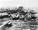
| Description: | An elevated view of Milwaukee Harbor with railroad station looking towards Lake Michigan. |

| Date: | 1866 |
|---|---|
| Description: | This map shows the railroads both completed and under construction in southern Wisconsin, Iowa, Illinois, and Missouri. Railroad terminals, junctions, and ... |

| Date: | 1867 |
|---|---|
| Description: | This map, which includes eastern Iowa, northern Illinois and the western portion of Michigan's Upper peninsula, shows the township survey grid and identifi... |

| Date: | 1858 |
|---|---|
| Description: | An ink on paper map of Milwaukee County and the eastern portion of Waukesha County that shows the townships of Oak Creek, Franklin, Greenfield, Wauwatosa, ... |

| Date: | 1886 |
|---|---|
| Description: | A hand-colored map of Milwaukee County, Wisconsin that shows the township and range system, sections, towns, roads, railroads and rail stations, cities and... |

| Date: | 1891 |
|---|---|
| Description: | A hand-colored map of Milwaukee County, Wisconsin that shows the township and range system, sections, towns, roads, railroads and rail stations, cities and... |

| Date: | 1902 |
|---|---|
| Description: | A map of Milwaukee County, Wisconsin that shows the township and range system, sections, towns, roads, railroads and rail stations, cities and villages, po... |

| Date: | 1968 |
|---|---|
| Description: | A tourist map of Milwaukee County and of downtown Milwaukee. The Map of Milwaukee County identifies the location of some of the points of interests in the ... |

| Date: | 1891 |
|---|---|
| Description: | This maps has an index of depots, hotels, prominent institutions and buildings, churches, and places of amusement. The map was removed from an unidentified... |

| Date: | 1903 |
|---|---|
| Description: | Map shows railroads, roads, street car lines, schools, churches, cemeteries, town halls, and railroad stations. Includes inset lists of: Population of Milw... |
If you didn't find the material you searched for, our Library Reference Staff can help.
Call our reference desk at 608-264-6535 or email us at: