 Filter: Categories of Wisconsin Historical Images
Filter: Subject of Railroad stations
Filter: Subject of postal service
Filter: Categories of Wisconsin Historical Images
Filter: Subject of Railroad stations
Filter: Subject of postal service
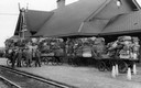
| Date: | 04 14 1948 |
|---|---|
| Description: | View across railroad tracks of cart loads of mail sacks on the platform, awaiting the arrival of the next train. The four men standing on the left have bee... |
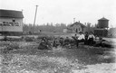
| Date: | |
|---|---|
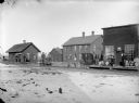
| Description: | A group of men near the Koss railroad depot, the majority of whom are seated on the ground. One of the men is sitting on a piano stool. To the right of the... |

| Date: | 1918 |
|---|---|
| Description: | Illinois Central Railroad station, 603 West Washington Avenue. The passenger depot is in the foreground, and the freight depot is across West Washington Av... |
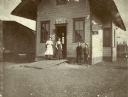
| Date: | |
|---|---|
| Description: | Two women and two young boys pose in front of the Koss Depot, which also serves as a post office and telegraph office. |
| Date: | 1914 |
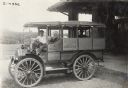
|---|---|
| Description: | Young man sitting in an International Model M truck used for transportation of passengers, the U.S. Mail, and the transport of luggage to hotels and depots... |
| Date: | |
|---|---|
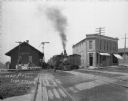
| Description: | View down railroad tracks of a busy scene at the train depot. A train is arriving at the crowded platform. On the side of the depot a man sits on a cart, n... |
| Date: | 1925 |
|---|---|
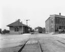
| Description: | View down railroad tracks of the Cuba City train depot and post office. |
| Date: | |
|---|---|
| Description: | Men at a railroad station awaiting the arrival of a train in Fremont (later Pray). There is snow on the ground. Two men are standing on a hand-powered rail... |

| Date: | 1858 |
|---|---|
| Description: | An ink on paper map of Milwaukee County and the eastern portion of Waukesha County that shows the townships of Oak Creek, Franklin, Greenfield, Wauwatosa, ... |

| Date: | 1886 |
|---|---|
| Description: | A hand-colored map of Milwaukee County, Wisconsin that shows the township and range system, sections, towns, roads, railroads and rail stations, cities and... |

| Date: | 1891 |
|---|---|
| Description: | A hand-colored map of Milwaukee County, Wisconsin that shows the township and range system, sections, towns, roads, railroads and rail stations, cities and... |

| Date: | 1902 |
|---|---|
| Description: | A map of Milwaukee County, Wisconsin that shows the township and range system, sections, towns, roads, railroads and rail stations, cities and villages, po... |

| Date: | 1899 |
|---|---|
| Description: | This 1899 map of Douglas County, Wisconsin, shows the township and range grid, towns, sections, cities, villages and railroad stations, mines, roads, railr... |

| Date: | 1896 |
|---|---|
| Description: | This 1896 map of Douglas County, Wisconsin, shows the township and range grid, the towns of Superior, Brule, Gordon, and Nebagamain, sections, cities and v... |

| Date: | 1878 |
|---|---|
| Description: | This bird’s-eye-view map of Barton is indexed for parochial and public schools, churches, a convent, the railroad depot, and the post office. |

| Date: | 1927 |
|---|---|
| Description: | This map includes an index and highways marked in red. Attractions on the map include: Four Mile House, Cold Springs, Grand Crossing Station, Coleman Sloug... |
If you didn't find the material you searched for, our Library Reference Staff can help.
Call our reference desk at 608-264-6535 or email us at: