 Filter: Categories of Wisconsin Historical Images
Filter: Subject of Railroad stations
Filter: Year of 1800-1899
Filter: Categories of Wisconsin Historical Images
Filter: Subject of Railroad stations
Filter: Year of 1800-1899

| Date: | 1863 |
|---|---|
| Description: | A map of Illinois showing all railroads, stations, and towns. |

| Date: | 1890 |
|---|---|
| Description: | People with horses and wagons are congregated at the railroad depot. |

| Date: | 1896 |
|---|---|
| Description: | A map of the Chain-O-Lakes in Waupaca, including Indian trails. The path of the Waupaca Electric Railway from the Grand View Hotel to the Wisconsin Central... |
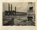
| Date: | 1865 |
|---|---|
| Description: | The ruins of a railroad depot after General Sherman's men burned the town near the end of the Civil War. Plate 61 |

| Date: | 1870 |
|---|---|
| Description: | View across water toward the back side of a railroad station and outbuilding that face the creek. A hotel, garage, and homes are around the structure. |
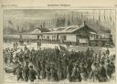
| Date: | 1870 |
|---|---|
| Description: | Crowd gathered at Chicago & St. Louis Railroad Station to see off a colony of emigrants from Chicago who planned to settle in Colorado on a tract of land p... |
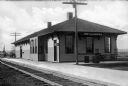
| Date: | 1880 |
|---|---|
| Description: | A view of the Weyauwega Train Depot building, platform, and railroad tracks. Signs on the building read, "Agency Western Express Co." and "Western Express ... |
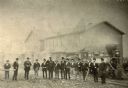
| Date: | 1872 |
|---|---|
| Description: | Employees of the West Wisconsin Railway stand in a line in front of Engine No. 12. From left to right are E.S. Graves (auditor's office clerk), A.H. Baldwi... |

| Date: | 1866 |
|---|---|
| Description: | This map shows the railroads both completed and under construction in southern Wisconsin, Iowa, Illinois, and Missouri. Railroad terminals, junctions, and ... |

| Date: | 1867 |
|---|---|
| Description: | This map, which includes eastern Iowa, northern Illinois and the western portion of Michigan's Upper peninsula, shows the township survey grid and identifi... |
| Date: | 1895 |
|---|---|
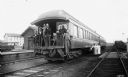
| Description: | Group of surveyors from the Agricultural Department at the University of Wisconsin posing on the back platform of their railroad car 404, "the Palace Car."... |

| Date: | 1858 |
|---|---|
| Description: | An ink on paper map of Milwaukee County and the eastern portion of Waukesha County that shows the townships of Oak Creek, Franklin, Greenfield, Wauwatosa, ... |

| Date: | 1886 |
|---|---|
| Description: | A hand-colored map of Milwaukee County, Wisconsin that shows the township and range system, sections, towns, roads, railroads and rail stations, cities and... |

| Date: | 1891 |
|---|---|
| Description: | A hand-colored map of Milwaukee County, Wisconsin that shows the township and range system, sections, towns, roads, railroads and rail stations, cities and... |

| Date: | 1899 |
|---|---|
| Description: | This 1899 map of Douglas County, Wisconsin, shows the township and range grid, towns, sections, cities, villages and railroad stations, mines, roads, railr... |

| Date: | 1898 |
|---|---|
| Description: | Map showing the contour depths of the lakes in northwestern Waukesha County, Wisconsin. Roads, railroads, depots, churches, schools, and hotels in the area... |

| Date: | 1896 |
|---|---|
| Description: | This 1896 map of Douglas County, Wisconsin, shows the township and range grid, the towns of Superior, Brule, Gordon, and Nebagamain, sections, cities and v... |

| Date: | 1891 |
|---|---|
| Description: | This maps has an index of depots, hotels, prominent institutions and buildings, churches, and places of amusement. The map was removed from an unidentified... |
| Date: | 1885 |
|---|---|
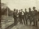
| Description: | Group of Wisconsin National Guardmen standing on a platform, possibly at the Union Depot in Camp Douglas. |

| Date: | 1800 |
|---|---|
| Description: | Shows plat of town, land ownership by name, local streets, courthouses, churches, hotels, mills, railroads, railroad stations, lakes, and rivers. Includes ... |
If you didn't find the material you searched for, our Library Reference Staff can help.
Call our reference desk at 608-264-6535 or email us at: