 Filter: Categories of Wisconsin Historical Images
Filter: Subject of Railroad stations
Filter: Year of 1800-1899
Filter: Categories of Wisconsin Historical Images
Filter: Subject of Railroad stations
Filter: Year of 1800-1899

| Date: | 1852 |
|---|---|
| Description: | Map created between 1852 and 1867 shows numbered lots, labelled roads, the "Centre Line of LaCrosse & Milwaukee R.R." railroad, and a station house. Roads ... |

| Date: | 1878 |
|---|---|
| Description: | This bird’s-eye-view map of Barton is indexed for parochial and public schools, churches, a convent, the railroad depot, and the post office. |

| Date: | 1870 |
|---|---|
| Description: | Section of overall panorama, showing railroad station. |

| Date: | 1898 |
|---|---|
| Description: | Men in a Chicago, Milwaukee & St. Paul railroad station. |

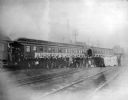
| Date: | 1895 |
|---|---|
| Description: | Employes of the Chicago, Milwaukee & St. Paul Railway and their wives, Mr. and Mrs. N.J. Edwards, W.H. Lenshan, E.B. McLaird, Alf. Hetig, and George McLair... |

| Date: | 1882 |
|---|---|
| Description: | Plat map of the village of Dunbarton, received by the Lafayette County Register's Office on September 22, 1892. Certification by the surveyor, Albert Pool,... |

| Date: | 1868 |
|---|---|
| Description: | This map is ink on tracing cloth and shows lot and block numbers, depot, railroads and side tracks, and streets in sections 24 and 25, T.11, R.16E. The map... |

| Date: | 1856 |
|---|---|
| Description: | This map shows lot and block numbers, streets, a mill, the Milwaukee and Mississippi Railroad, the train depot, and the Kickapoo River. Included in the low... |
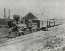
| Date: | 1870 |
|---|---|
| Description: | Slightly elevated view of a Chicago & Northwestern Railway train at a depot in an unidentified town. The railroad station is behind the train. On the right... |

| Date: | 1856 |
|---|---|
| Description: | This map shows lot and block numbers, streets, depot building, and the Milwaukee & Mississippi Rail Road. |

| Date: | 1892 |
|---|---|
| Description: | This map shows schools, engine houses, railroads, street railways, wards, parks, cemeteries, block numbers, a street index, explanations, and general refer... |
| Date: | 1896 |
|---|---|
| Description: | View across railroad tracks towards a group of glee, banjo and mandolin club members posing in front of a University of Wisconsin banner on the Chicago and... |

| Date: | 1892 |
|---|---|
| Description: | A Sanborn map of St. Louis, which is six miles southwest of South Superior. |
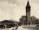
| Date: | 1892 |
|---|---|
| Description: | View of the Chicago & Northwestern Railroad station in Milwaukee. A couple is sitting on a bench under an umbrella in the foreground. The baggage car of a ... |
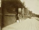
| Date: | 1898 |
|---|---|
| Description: | View down platform of Lakewood train station, with two men standing near a doorway on the left near two sacks. Another man is further down the platform ben... |

| Date: | 10 1894 |
|---|---|
| Description: | A Sanborn Fire Insurance Map of Waunakee. |
If you didn't find the material you searched for, our Library Reference Staff can help.
Call our reference desk at 608-264-6535 or email us at: