Filter: Categories of Wisconsin Historical Images
Filter: Subject of Railroad trains
Filter: Type of Photograph
Filter: Subject of aerial photographs
Filter: Categories of Wisconsin Historical Images
Filter: Subject of Railroad trains
Filter: Type of Photograph
Filter: Subject of aerial photographs

| Date: | |
|---|---|
| Description: | Aerial view of a train crossing the East River in a rural community south of Green Bay. Some buildings are visible to the right and the background of the i... |
| Date: | |
|---|---|
| Description: | Aerial view looking north of downtown, with the Milwaukee River and Lake Michigan. |

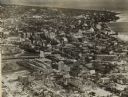
| Date: | |
|---|---|
| Description: | An aerial view of the port and a section of the city showing a large boat, a railway depot, a park plaza and a grid of city streets with large buildings. |

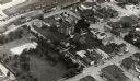
| Date: | 1930 |
|---|---|
| Description: | Aerial view of International Harvester's Milwaukee Works. |
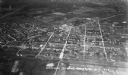
| Date: | 1935 |
|---|---|
| Description: | Aerial view, taken from an airplane, overlooking the streets, houses, stores, trees and railroad cars. |

| Date: | 1967 |
|---|---|
| Description: | Air view looking north toward Lake Mendota. The intersection of West Washington Ave. and S. Park Street is at bottom center. The Triangle Redevelopment Pro... |
If you didn't find the material you searched for, our Library Reference Staff can help.
Call our reference desk at 608-264-6535 or email us at: