 Filter: Categories of Wisconsin Historical Images
Filter: Subject of Railroads
Filter: County of Dane
Filter: Type of Map or Atlas
Filter: Year of 1900-1999
Filter: Categories of Wisconsin Historical Images
Filter: Subject of Railroads
Filter: County of Dane
Filter: Type of Map or Atlas
Filter: Year of 1900-1999

| Date: | 1908 |
|---|---|
| Description: | Colored map showing a panoramic view of Madison in great detail. The Wisconsin State Capitol is located at the center, with Lake Mendota in the background ... |

| Date: | 1911 |
|---|---|
| Description: | Plat Map of Blooming Grove in "Atlas of Dane County, Wisconsin." |

| Date: | 1904 |
|---|---|
| Description: | This map shows a plat of the east part of the city, numbered blocks and lots, some landownership, local streets, roads, railroads, wards by number, parks, ... |

| Date: | 1904 |
|---|---|
| Description: | This map shows a plat of the west part of the city, numbered blocks and lots, some landownership, local streets, roads, railroads, wards by number, parks, ... |

| Date: | 1900 |
|---|---|
| Description: | A hydrographic map of Lake Monona and the adjacent topography. |

| Date: | 1911 |
|---|---|
| Description: | A map of the village of Black Earth and Verona. |

| Date: | 1931 |
|---|---|
| Description: | A map of the village of Verona, Wisconsin. |

| Date: | 1906 |
|---|---|
| Description: | Hand-drawn topographical map of the Turville Estate. |

| Date: | 1906 |
|---|---|
| Description: | Topographical map of Turville Point and lands to the South to Nine Springs Creek. |

| Date: | 1953 |
|---|---|
| Description: | A map of Lake Mendota that shows depths and the locations of various species of fish in lake. The maps also identifies a number of selected roads and stree... |

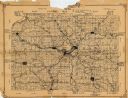
| Date: | 1904 |
|---|---|
| Description: | This 1904 map of Dane County, Wisconsin, shows postal routes, post office locations, towns, sections, cities and villages, roads, railroads, collection box... |

| Date: | 1909 |
|---|---|
| Description: | This 1909 bird's-eye view of Madison and the surrounding Four Lakes region shows roads, railroads, selected buildings in Madison, and points of interest ar... |
| Date: | 1922 |
|---|---|
| Description: | This 1922 map of Dane County, Wisconsin, issued by the Madison Association of Commerce shows the township and range grid, towns, sections, cities and villa... |

| Date: | 1924 |
|---|---|
| Description: | This map of the Four Lakes region shows points of interest around the lakes, state trunk highways and other roads, railroads, and lakes and streams. Manusc... |

| Date: | 1925 |
|---|---|
| Description: | This 1925 map of Dane County, Wisconsin, issued by the Madison Association of Commerce shows the township and range grid, towns, sections, cities and villa... |

| Date: | 1914 |
|---|---|
| Description: | Shows land ownership by name, rural routes, improved roads, railroads, schools, churches, and cemeteries. "For list of small property owners, lift map at f... |

| Date: | 1942 |
|---|---|
| Description: | This 1942 map of the Town of Middleton, Dane County, Wisconsin, shows sections, landowners, highways and roads, a railroad, the village of Middleton, and l... |
If you didn't find the material you searched for, our Library Reference Staff can help.
Call our reference desk at 608-264-6535 or email us at:


