 Filter: Categories of Wisconsin Historical Images
Filter: Subject of Railroads
Filter: County of Dane
Filter: Subject of dwellings
Filter: Categories of Wisconsin Historical Images
Filter: Subject of Railroads
Filter: County of Dane
Filter: Subject of dwellings
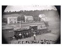
| Date: | 1873 |
|---|---|
| Description: | Elevated view of several men, some of whom may be railroad workers, posing in front of a Minnesota and St. Paul wood-burning engine at a train crossing. Th... |
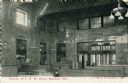
| Date: | 1912 |
|---|---|
| Description: | Interior view of the Chicago & Northwestern Railroad depot. A man is seated on one of the benches. Caption reads: "Interior of C. N. W. Depot, Madison, Wis... |
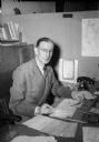
| Date: | 11 04 1944 |
|---|---|
| Description: | Harry G. Marsh, passenger agent for the Chicago & Northwestern Railroad, seated at his desk. Mr. Marsh was responsible for troop movements to and from Trua... |
| Date: | 01 22 1949 |
|---|---|
| Description: | Aerial view of the town and the Chicago, Milwaukee, St. Paul and Pacific railroad bridge. |

| Date: | 02 25 1949 |
|---|---|
| Description: | One of six aerial images of Mount Horeb. |
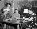
| Date: | 04 20 1949 |
|---|---|
| Description: | Four women who attended the dessert bridge party given by the Milwaukee Railroad Women's Club for the Northwestern Railroad Women's Club at Manchester's Ma... |
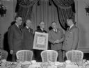
| Date: | 03 22 1950 |
|---|---|
| Description: | Walter S. Alcumbrac, Madison superintendent of the Madison division of the Chicago and North Western Railway Company, (right) receives a plaque for the bes... |
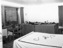
| Date: | 11 29 1951 |
|---|---|
| Description: | Interior view of the David & Florence Bade residence at 5701 Winnequah Road in Frost Woods, Monona. The photograph shows Jimmy's (age 8) bedroom, including... |
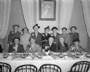
| Date: | 09 25 1952 |
|---|---|
| Description: | Group portrait of the guests of honor at the annual fall luncheon of the Chicago and Northwestern Railroad Woman's Club. The guests of honor were eleven ch... |

| Date: | 1923 |
|---|---|
| Description: | Map showing the parcel of land on the shore of Lake Monona acquired by the City of Madison for a park (today known as Olbrich Park). |

| Date: | 1927 |
|---|---|
| Description: | This Blue line print map shows trade area boundaries, lakes, farm homes, railways, high schools, public highways, and townships. A symbol key is included i... |

| Date: | 12 1912 |
|---|---|
| Description: | Sanborn map of Sun Prairie, which includes an index and information about water facilities and the fire department. Includes a small inset map of the State... |

| Date: | 06 1960 |
|---|---|
| Description: | Aerial view looking northwest showing an area to be redeveloped into high-rise dormitories. Lake Mendota and Bascom Woods can be seen at the top. Universit... |

| Date: | 1967 |
|---|---|
| Description: | Air view looking north toward Lake Mendota. The intersection of West Washington Ave. and S. Park Street is at bottom center. The Triangle Redevelopment Pro... |

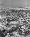
| Date: | |
|---|---|
| Description: | Aerial view of the Greenbush neighborhood in winter partially demolished for the Triangle Redevelopment Project. Monona Bay and Brittingham park are at rig... |

| Date: | 05 19 1959 |
|---|---|
| Description: | Henry Cuccia, a ninth-grader at Cherokee Heights school, demonstrates "what not to do" on the Illinois Central railroad tracks near the school as he walks ... |

| Date: | 10 1894 |
|---|---|
| Description: | A Sanborn Fire Insurance Map of Waunakee. |
If you didn't find the material you searched for, our Library Reference Staff can help.
Call our reference desk at 608-264-6535 or email us at: