 Filter: Categories of Wisconsin Historical Images
Filter: Subject of Railroads
Filter: County of Dane
Filter: Subject of human settlements
Filter: Categories of Wisconsin Historical Images
Filter: Subject of Railroads
Filter: County of Dane
Filter: Subject of human settlements

| Date: | 1854 |
|---|---|
| Description: | This mid-19th century map of Dane County, Wisconsin, shows the township and range grid, towns, sections, cities, villages and post offices, lakes and strea... |

| Date: | 1890 |
|---|---|
| Description: | Shows towns of Dane County, lakes, rivers, and railroads. Relief shown by hachures. Includes color illustration of Madison and text describing Dane County ... |

| Date: | 1899 |
|---|---|
| Description: | These two maps of Madison and the Four Lakes region show the site of the Teachers Country Club on Lake Monona, the lakes and the Catfish or Yahara River, f... |

| Date: | 1904 |
|---|---|
| Description: | This 1904 map of Dane County, Wisconsin, shows postal routes, post office locations, towns, sections, cities and villages, roads, railroads, collection box... |

| Date: | 1909 |
|---|---|
| Description: | This 1909 bird's-eye view of Madison and the surrounding Four Lakes region shows roads, railroads, selected buildings in Madison, and points of interest ar... |
| Date: | 1922 |
|---|---|
| Description: | This 1922 map of Dane County, Wisconsin, issued by the Madison Association of Commerce shows the township and range grid, towns, sections, cities and villa... |

| Date: | 1924 |
|---|---|
| Description: | This map of the Four Lakes region shows points of interest around the lakes, state trunk highways and other roads, railroads, and lakes and streams. Manusc... |

| Date: | 1925 |
|---|---|
| Description: | This 1925 map of Dane County, Wisconsin, issued by the Madison Association of Commerce shows the township and range grid, towns, sections, cities and villa... |

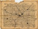
| Date: | 1890 |
|---|---|
| Description: | This late-19th century map of Dane County, Wisconsin, shows the township and range grid, towns, sections, cities and villages, lakes and streams, roads, an... |

| Date: | 1854 |
|---|---|
| Description: | Shows street grid, sections in adjacent townships, routes of railroads and projected railroads, post offices, and creeks. Table of references identifies ma... |

| Date: | 1914 |
|---|---|
| Description: | Shows land ownership by name, rural routes, improved roads, railroads, schools, churches, and cemeteries. "For list of small property owners, lift map at f... |

| Date: | 1942 |
|---|---|
| Description: | This 1942 map of the Town of Middleton, Dane County, Wisconsin, shows sections, landowners, highways and roads, a railroad, the village of Middleton, and l... |

| Date: | 1917 |
|---|---|
| Description: | Shows property already platted (orange), public property (green), street railway (red lines), Lake Forest development area (red), and some landownership. T... |

| Date: | 1943 |
|---|---|
| Description: | Shows Madison city limits with thick solid lines and ward districts with dotted lines. The wards are numbered, and points of interests and land marks are l... |

| Date: | 1887 |
|---|---|
| Description: | City water works system map. Pencil annotation on the top right reads: "Period represented is after 1887 and before Aug. 1891". The middle of the map has a... |

| Date: | 1896 |
|---|---|
| Description: | Shows pipes of various sizes, hydrants with hydrant pressure, valves, wells, projected lines, and suction pipes. Differs from earlier versions by inclusion... |

| Date: | 1898 |
|---|---|
| Description: | Shows landownership, buildings, and railroads. Lake Mendota and Lake Wingra are labelled. |

| Date: | 1905 |
|---|---|
| Description: | This map shows roads, railroads, and location of Keyes Springs, now part of Monona. The map reads: "L.S. Smith, c.e., del. May, 1905" and "For further info... |

| Date: | 1910 |
|---|---|
| Description: | Shows existing and proposed parks, railroads, and marshes in a color coded key. "Contour interval 20 feet." Lake Wingra, Lake Mendota, and Lake Monona are ... |
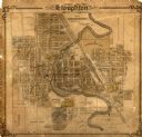
| Date: | 1906 |
|---|---|
| Description: | This map of Stoughton shows plat additions, numbered lots, some land ownership, and labeled streets. The map is color coded in blue, pink, and yellow altho... |
If you didn't find the material you searched for, our Library Reference Staff can help.
Call our reference desk at 608-264-6535 or email us at: