 Filter: Categories of Wisconsin Historical Images
Filter: Subject of Railroads
Filter: County of Dane
Filter: Year of 1900-1999
Filter: Year of 1910-1919
Filter: Categories of Wisconsin Historical Images
Filter: Subject of Railroads
Filter: County of Dane
Filter: Year of 1900-1999
Filter: Year of 1910-1919

| Date: | 1911 |
|---|---|
| Description: | Plat Map of Blooming Grove in "Atlas of Dane County, Wisconsin." |

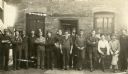
| Date: | 1915 |
|---|---|
| Description: | The Chicago, Milwaukee, and St. Paul Railway freight depot, 40 North Frances Street. Men posing in front of the depot from left to right are: William Dunn... |
| Date: | 1913 |
|---|---|
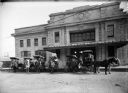
| Description: | Horse-drawn American Express wagons in front of the Chicago & Northwestern Railway depot. |
| Date: | 1912 |
|---|---|
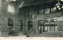
| Description: | Interior view of the Chicago & Northwestern Railroad depot. A man is seated on one of the benches. Caption reads: "Interior of C. N. W. Depot, Madison, Wis... |
| Date: | 1910 |
|---|---|
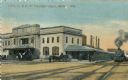
| Description: | The Chicago & Northwestern Railway passenger depot. Caption reads: "C. & N. W. Passenger Depot, Madison, Wis." |
| Date: | 1910 |
|---|---|
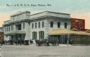
| Description: | View across street toward the Chicago & Northwestern Railroad Depot. Caption reads: "New C. & N. W. R. R. Depot, Madison, Wis." |
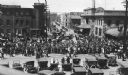
| Date: | 05 25 1918 |
|---|---|
| Description: | A crowd watching as drafted men leave Madison via the Chicago Northwestern railroad station. |
| Date: | 1913 |
|---|---|
| Description: | A group of railway shopmen of the Chicago, Milwaukee, and St. Paul Railroad pose at the terminal roundhouse in Madison's west side yards bordering Regent S... |

| Date: | 1918 |
|---|---|
| Description: | The West Madison Chicago, Milwaukee, and St. Paul railroad station, with train cars on the tracks. |

| Date: | 1911 |
|---|---|
| Description: | A map of the village of Black Earth and Verona. |

| Date: | 1914 |
|---|---|
| Description: | Shows land ownership by name, rural routes, improved roads, railroads, schools, churches, and cemeteries. "For list of small property owners, lift map at f... |

| Date: | 1917 |
|---|---|
| Description: | Shows property already platted (orange), public property (green), street railway (red lines), Lake Forest development area (red), and some landownership. T... |

| Date: | 1910 |
|---|---|
| Description: | Shows existing and proposed parks, railroads, and marshes in a color coded key. "Contour interval 20 feet." Lake Wingra, Lake Mendota, and Lake Monona are ... |

| Date: | 1911 |
|---|---|
| Description: | A plat map of the township of Westport in Dane County. |

| Date: | 02 17 1913 |
|---|---|
| Description: | Cyanotype menu for a Railroad Commission Dinner Dance, with a train steaming down the tracks, the seal of the state of Wisconsin, and two presentations of ... |

| Date: | 1914 |
|---|---|
| Description: | This map shows plat of the town, city limits, numbered blocks and lots, wards, local streets, roads, railroads, Capitol Square, Vilas Park, Edgewood Academ... |

| Date: | 1914 |
|---|---|
| Description: | This map shows a plat of the town, city limits, numbered blocks and lots, wards, local streets, roads, railroads, Capitol Square, Vilas Park, Edgewood Acad... |

| Date: | 1910 |
|---|---|
| Description: | This maps is pen and pencil on tracing cloth and shows local streets, buildings, proposed and present branches of railroad track, and sewer and water lines... |
If you didn't find the material you searched for, our Library Reference Staff can help.
Call our reference desk at 608-264-6535 or email us at:

