 Filter: Categories of Wisconsin Historical Images
Filter: Subject of Railroads
Filter: County of Jackson
Filter: Subject of water
Filter: Categories of Wisconsin Historical Images
Filter: Subject of Railroads
Filter: County of Jackson
Filter: Subject of water

| Date: | 1875 |
|---|---|
| Description: | Bird's-eye map of Black River Falls, looking southwest. |
| Date: | |
|---|---|
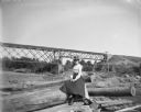
| Description: | A woman sits among a group of logs on the shoreline of a river. In the background, a railroad bridge is visible. |
| Date: | |
|---|---|
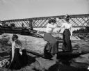
| Description: | Three women playfully pose among logs near a railroad bridge that passes over a dam. On the bridge, a standing man is visible. |

| Date: | 1883 |
|---|---|
| Description: | This birdseye view map reads: ""MERRILLAN JACKSON COUNTY, WISCONSIN. LOOKING FROM POSITION NORTH EAST ON THE TOWN." At the bottom are points to interest th... |

| Date: | 1879 |
|---|---|
| Description: | A map of Jackson County, Wisconsin, shows the township and section survey, landownership, towns, villages, buildings, roads, railroads, county land, and st... |

| Date: | 1976 |
|---|---|
| Description: | Panel title. Shows railroads, roads, highways, boundaries, dams, public hunting and fishing grounds, cemeteries, forest ranger stations, plant life, and s... |
| Date: | |
|---|---|
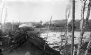
| Description: | A view of logs transported by rail heading toward a group of buildings. A man is sitting on a stack of logs on the left. Other logs are floating in the wat... |

| Date: | 1901 |
|---|---|
| Description: | Plat map showing land ownership of Township 21N Range 3W in Jackson County for 1901. Scale is 2 inches to 1 mile. |
If you didn't find the material you searched for, our Library Reference Staff can help.
Call our reference desk at 608-264-6535 or email us at: