 Filter: Categories of Wisconsin Historical Images
Filter: Subject of Railroads
Filter: County of Jackson
Filter: Categories of Wisconsin Historical Images
Filter: Subject of Railroads
Filter: County of Jackson
| Date: | |
|---|---|
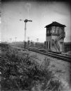
| Description: | View across railroad tracks towards a railroad signal tower. Location identified as the signal tower for the Sheppard's cut-off south of Black River Falls. |
| Date: | |
|---|---|
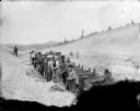
| Description: | Elevated view of workmen building the main railroad line from Black River Falls to Vaudreuil. |

| Date: | |
|---|---|
| Description: | A man and his dog are sitting on a cart pulled by two horses at a rural intersection on a muddy road. There is a corner of a building with a billboard on t... |
| Date: | |
|---|---|
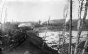
| Description: | A view of logs transported by rail heading toward a group of buildings. A man is sitting on a stack of logs on the left. Other logs are floating in the wat... |

| Date: | 1901 |
|---|---|
| Description: | Plat map showing land ownership of Township 21N Range 3W in Jackson County for 1901. Scale is 2 inches to 1 mile. |
If you didn't find the material you searched for, our Library Reference Staff can help.
Call our reference desk at 608-264-6535 or email us at: