 Filter: Categories of Wisconsin Historical Images
Filter: Subject of Railroads
Filter: Subject of railroads
Filter: Subject of land
Filter: Categories of Wisconsin Historical Images
Filter: Subject of Railroads
Filter: Subject of railroads
Filter: Subject of land

| Date: | 1856 |
|---|---|
| Description: | A Wisconsin map showing the Wisconsin Superior and St. Croix Railroad. |

| Date: | 1900 |
|---|---|
| Description: | A hydrographic map of Lake Monona and the adjacent topography. |

| Date: | 1911 |
|---|---|
| Description: | A map of the village of Black Earth and Verona. |
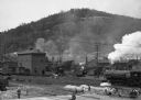
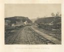
| Date: | |
|---|---|
| Description: | Elevated view of men working on the railroad tracks. There are locomotives and railroad cars on the tracks. Some children are standing on the tracks near t... |
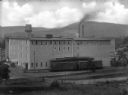
| Date: | |
|---|---|
| Description: | Elevated view of a factory in Youngsville, with a railroad car and railroad tracks in front of it. In the background is a hill or mountain. |

| Date: | |
|---|---|
| Description: | Elevated view of a small settlement between two mountains and alongside a river with tracks of the first transcontinental railroad passing through. A bridg... |
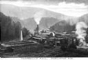
| Date: | |
|---|---|
| Description: | Elevated view of Campbell's Mill, which specialized in lumber. Situated in the midst of the forest are smokestacks, railroad tracks, and several buildings.... |
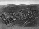
| Date: | |
|---|---|
| Description: | Aerial view of the Edison Portland Cement Company, founded by Thomas A. Edison in 1902. The company introduced the use of long kilns. Caption reads: "Plant... |
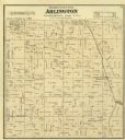
| Date: | 1873 |
|---|---|
| Description: | Columbia County Atlas Arlington Township 10 North Range 9 East. |
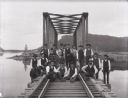
| Date: | 1890 |
|---|---|
| Description: | A railroad section crew poses with a handcar on the trestle spanning the Buffalo River, north of Alma, Wisconsin. |
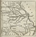
| Date: | |
|---|---|
| Description: | Map of Missouri with major cities, rivers, and railroads marked. |

| Date: | 1913 |
|---|---|
| Description: | A wall atlas of Sauk County, Wisconsin, displaying its 22 towns. On the left side are advertisements for local businesses. |

| Date: | 1931 |
|---|---|
| Description: | A map of the village of Verona, Wisconsin. |

| Date: | 1877 |
|---|---|
| Description: | Map of northern Wisconsin showing the lands owned by Cornell University (shaded portions) in 1877. The map depicts the lakes, river systems, towns, and th... |

| Date: | 1930 |
|---|---|
| Description: | Pictorial map of Glacier National Park, Montana and Waterton Lakes National Park, Alberta. Illustrated by Joe Scheurle, it depicts white people, American ... |
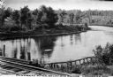
| Date: | |
|---|---|
| Description: | View of the Flambeau River from Soo Bridge. The railroad bridges crosses over the river and foliage lines the riverbanks. |
| Date: | 1866 |
|---|---|
| Description: | View from railroad tracks through the Allatoona Pass. One of the buildings on the left says "Grocery," and piles of lumber are stacked along the sides of t... |
If you didn't find the material you searched for, our Library Reference Staff can help.
Call our reference desk at 608-264-6535 or email us at:


