 Filter: Categories of Wisconsin Historical Images
Filter: Subject of Real estate development
Filter: Creator Name of Unknown
Filter: Subject of water
Filter: Categories of Wisconsin Historical Images
Filter: Subject of Real estate development
Filter: Creator Name of Unknown
Filter: Subject of water

| Date: | 1914 |
|---|---|
| Description: | This map is a photostat copy from the original 1829 map in the War Department. The map shows location of Fort Howard, lots, land claims of Jacques Porlier ... |

| Date: | 1835 |
|---|---|
| Description: | This map is pen-and-ink on paper. The map shows landowners in "Milwalky" or present day Milwaukee. Includes "list of property offered to Mr. Walker". The m... |

| Date: | 06 1837 |
|---|---|
| Description: | Pen-and-ink on paper. Shows riverside property west of the Milwaukee River. Inscribed by several early Milwaukee settlers, including Henry W. Cleveland, Cy... |

| Date: | 1939 |
|---|---|
| Description: | This is a zoning map of Wauwatosa with a key of districts including agricultural, resident, business, commercial, and industrial. The map features labeled ... |

| Date: | 1900 |
|---|---|
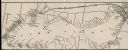
| Description: | This photocopied map shows private claim owners, buildings, and land use in 1818. Insets show Fort Howard and the caption reads: "A view of the Fox River ... |
| Date: | 1900 |
|---|---|
| Description: | A map of Lake Geneva, including the villages of Williams Bay and Fontana, and a portion of the city of Lake Geneva. The Chicago and Northwestern Railway li... |
If you didn't find the material you searched for, our Library Reference Staff can help.
Call our reference desk at 608-264-6535 or email us at: