 Filter: Categories of Wisconsin Historical Images
Filter: Subject of Religion
Filter: Subject of church buildings
Filter: Subject of service industries
Filter: Categories of Wisconsin Historical Images
Filter: Subject of Religion
Filter: Subject of church buildings
Filter: Subject of service industries

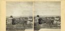
| Date: | 1898 |
|---|---|
| Description: | Bird's-eye map of Milwaukee with prominent streets and buildings identified. Taken from City Hall Tower. |
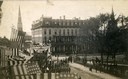
| Date: | 10 07 1887 |
|---|---|
| Description: | Military parade on Main Street honoring President Grover Cleveland's visit to Madison. Soldiers of the University Battalion are marching on West Main Stree... |
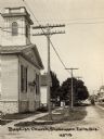
| Date: | 1920 |
|---|---|
| Description: | View down road and sidewalk towards a Baptist church. Caption reads: "Baptist Church, Sheboygan Falls, Wis." |
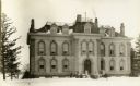
| Date: | 1920 |
|---|---|
| Description: | Cistercian Abbey of Cistercian Fathers, Our Lady of Spring Bank in winter. Formerly a resort hotel on Oconomowoc Lake, called Spring Bank. |
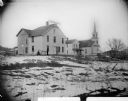
| Date: | |
|---|---|
| Description: | Portrait of several buildings and a snowy landscape, probably in Hixton. A man is standing outside the first building on the left, which has a sign on the ... |
| Date: | |
|---|---|
| Description: | Elevated view up Wisconsin Avenue showing City Hall with the Post Office to the right. Also visible is the Presbyterian Church. |
| Date: | |
|---|---|
| Description: | Three-quarter view of the front and side of the Lutheran Church. The building features two steeples, arched windows, and rose windows. |
| Date: | |
|---|---|
| Description: | View of a Lutheran Church featuring a large clock tower and two steeples, rose and arched windows, and an arched entrance with stairs leading up to it. An... |

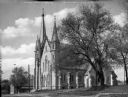
| Date: | |
|---|---|
| Description: | Exterior view from across road of the Methodist Evangelical Church. The building has arched windows and a bell tower. Above the entrance is a round window... |

| Date: | 1911 |
|---|---|
| Description: | Exterior of the Methodist Evangelical Church. A small boy sits on the curb along the cobblestone street outside the building. Next door to the church is Ho... |
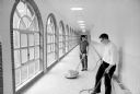
| Date: | 05 27 1965 |
|---|---|
| Description: | The seminarians at Holy Name Seminary learn that the dignity of manual labor is an important lesson for aspirants to the priesthood. Here Tom Colt, Madison... |

| Date: | 1857 |
|---|---|
| Description: | This map shows lot and block numbers, buildings, some land ownership, wards, waterways, streets, railroads, brick yards, and cemeteries. It includes an ind... |

| Date: | 1905 |
|---|---|
| Description: | This photocopied map shows landownership, roads, railroads, rural mail routes, churches, school houses, cemeteries, and townships. The map includes adverti... |

| Date: | 1900 |
|---|---|
| Description: | This map shows landownership, railroads, roads, churches, schools, cemeteries, post offices, townships, city wards, Lake Michigan, and rivers. The map incl... |

| Date: | 1902 |
|---|---|
| Description: | This map shows townships, land parcels, schools, rivers, lakes, creameries, churches, cemeteries, roads, post offices, town halls, saw mills, roads and sto... |

| Date: | 2004 |
|---|---|
| Description: | This map shows ATMs, houses of worship, hotels, parking ramps, public parking, union cab stands, bus stops, business district, parks and public areas, gove... |

| Date: | |
|---|---|
| Description: | Black and white postcard of a view across water towards the Roger Williams Inn (now the Green Lake Conference Center), main building of the American Baptis... |
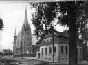
| Date: | 1907 |
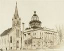
|---|---|
| Description: | View facing north east across Hancock Street towards the Evangelical Reformed Church, also known as the German Reformed Church, and the new Manitowoc Count... |
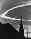
| Date: | 1960 |
|---|---|
| Description: | A circular contrail forming a halo behind a silhouetted church steeple. Power lines are in the background. |
If you didn't find the material you searched for, our Library Reference Staff can help.
Call our reference desk at 608-264-6535 or email us at: