 Filter: Categories of Wisconsin Historical Images
Filter: Subject of Religion
Filter: Subject of ferries
Filter: Categories of Wisconsin Historical Images
Filter: Subject of Religion
Filter: Subject of ferries

| Date: | 1789 |
|---|---|
| Description: | Map of New York City showing ward boundaries, ferries, streets, roads, swamps, ponds, and rivers. The properties of Lispinard, Byards, Jones, Rutgers, and ... |
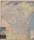
| Date: | 1954 |
|---|---|
| Description: | This map is designed to help Catholic tourists in Wisconsin find Catholic churches and missions. On the front side, a road map of Wisconsin showing the loc... |
If you didn't find the material you searched for, our Library Reference Staff can help.
Call our reference desk at 608-264-6535 or email us at: