 Filter: Categories of Wisconsin Historical Images
Filter: Subject of Religion
Filter: Subject of fortification
Filter: Categories of Wisconsin Historical Images
Filter: Subject of Religion
Filter: Subject of fortification

| Date: | 1942 |
|---|---|
| Description: | These three maps depict the locations of French missions and French forts in Wisconsin, as well as the French place names in the state. |

| Date: | 1719 |
|---|---|
| Description: | Map of the Great Lakes and the St. Lawrence river showing French and English cities and villages, trading posts, Indian villages and tribes, portages, for... |

| Date: | 1760 |
|---|---|
| Description: | Map showing upstate New York, Lake Ontario, and the St. Lawrence River during the last, decisive battle of the French and Indian War. The main map shows a ... |
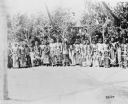
| Date: | 1900 |
|---|---|
| Description: | A group of men posing together in front of a stand of trees. Caption reads: "Indian 'Sun Dance' near Fort Washakie, Wyo, 1900." |
If you didn't find the material you searched for, our Library Reference Staff can help.
Call our reference desk at 608-264-6535 or email us at: