 Filter: Categories of Wisconsin Historical Images
Filter: Subject of Religion
Filter: Subject of maps
Filter: Categories of Wisconsin Historical Images
Filter: Subject of Religion
Filter: Subject of maps
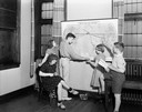
| Date: | 06 07 1938 |
|---|---|
| Description: | Five children looking at map of Presbyterian missions located throughout the world, at Christ Presbyterian Church, located at 124 Wisconsin Avenue. |
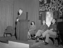
| Date: | 11 14 1945 |
|---|---|
| Description: | Professor Walter Agard addressing an all-campus rally on the Palestine question held at the Memorial Union. Seated left to right: Elaine Sermopskie, Topeka... |
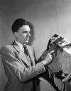
| Date: | 02 22 1948 |
|---|---|
| Description: | The Rev. James C. Flint, former minister to the Congregational students at the University of Wisconsin, pointing to a map of Europe as part of a lecture ab... |
| Date: | |
|---|---|
| Description: | A sign above a large map of Wisconsin counties is in Latin: "Pro Deo Et Patria," meaning For God and Country, and on the left is a decorated cross, on top ... |
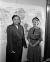
| Date: | 09 27 1953 |
|---|---|
| Description: | "Building Lasting Peace" is the theme for World Community Day, sponsored by the Madison Council of United Church Women at Grace Episcopal Church. Pictured ... |

| Date: | 09 1894 |
|---|---|
| Description: | This map shows Congregational churches and Home Missionary churches. County boundaries and county seats are also labeled. The original caption reads, "Cong... |

| Date: | 1902 |
|---|---|
| Description: | This map shows townships, land parcels, schools, rivers, lakes, creameries, churches, cemeteries, roads, post offices, town halls, saw mills, roads and sto... |

| Date: | 1710 |
|---|---|
| Description: | A seminal and fairly accurate map of the Great Lakes Region up to Baffin's Bay in Northern Canada. This is possibly the first printed map to locate Detroit... |

| Date: | 1795 |
|---|---|
| Description: | Map of Connecticut showing counties, townships, cities, roads, islands, swamps, hills, mountains, lakes, rivers, reefs, and numerous other geographical and... |

| Date: | 1865 |
|---|---|
| Description: | Portrait of Reverend Edward Mathews standing in front of a "Moral Map of the United States." He is holding a long, wooden pointer and is gesturing towards ... |
If you didn't find the material you searched for, our Library Reference Staff can help.
Call our reference desk at 608-264-6535 or email us at: