 Filter: Categories of Wisconsin Historical Images
Filter: Subject of Religion
Filter: Subject of postal service
Filter: Categories of Wisconsin Historical Images
Filter: Subject of Religion
Filter: Subject of postal service

| Date: | 1918 |
|---|---|
| Description: | Wisconsin State Capitol from Wisconsin Avenue, with the United States Federal Courthouse and Post Office on the left, and Madison City Hall and Christ Pres... |
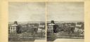
| Date: | |
|---|---|
| Description: | Elevated view up Wisconsin Avenue showing City Hall with the Post Office to the right. Also visible is the Presbyterian Church. |

| Date: | 1905 |
|---|---|
| Description: | This photocopied map shows landownership, roads, railroads, rural mail routes, churches, school houses, cemeteries, and townships. The map includes adverti... |

| Date: | 1900 |
|---|---|
| Description: | This map shows landownership, railroads, roads, churches, schools, cemeteries, post offices, townships, city wards, Lake Michigan, and rivers. The map incl... |

| Date: | 1902 |
|---|---|
| Description: | This map shows townships, land parcels, schools, rivers, lakes, creameries, churches, cemeteries, roads, post offices, town halls, saw mills, roads and sto... |

| Date: | |
|---|---|
| Description: | Front page of the fake, humorous newsletter titled Dells Events. The front page includes a color picture of two girls (Katie and Jessica Trumble) po... |
If you didn't find the material you searched for, our Library Reference Staff can help.
Call our reference desk at 608-264-6535 or email us at: