 Filter: Categories of Wisconsin Historical Images
Filter: Subject of Religion
Filter: Subject of suburbs
Filter: Categories of Wisconsin Historical Images
Filter: Subject of Religion
Filter: Subject of suburbs
| Date: | |
|---|---|
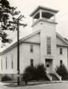
| Description: | View towards front and left side of the First Presbyterian Church. |

| Date: | 1969 |
|---|---|
| Description: | This map is pen and ink on paper and shows the location of churches, local streets, railroads, parks, Middleton, Shorewood Hills, Monona, Maple Bluff, McFa... |

| Date: | 1956 |
|---|---|
| Description: | This map shows city, suburban, parochial and other types schools, with an explanation of symbols in the right margin. The original caption for the map read... |

| Date: | 1966 |
|---|---|
| Description: | This map shows city, suburban, parochial and other types schools, with an explanation of symbols in the right margin. The original caption for the map read... |
If you didn't find the material you searched for, our Library Reference Staff can help.
Call our reference desk at 608-264-6535 or email us at: