 Filter: Categories of Wisconsin Historical Images
Filter: Subject of Rivers
Filter: Year of 1900-1999
Filter: Type of Map or Atlas
Filter: Categories of Wisconsin Historical Images
Filter: Subject of Rivers
Filter: Year of 1900-1999
Filter: Type of Map or Atlas
| Date: | 1974 |
|---|---|
| Description: | This map is a 9 part map detailing various parts of Menominee County, Wisconsin. Page 1 of the map shows federal aid control in the county and was used by ... |

| Date: | 1976 |
|---|---|
| Description: | An 1876 reprinted map of the Township of Franklin, Milwaukee County, Wisconsin, that shows the land ownership and sectioning of the town, as well as the ro... |

| Date: | 1902 |
|---|---|
| Description: | A map of Milwaukee County, Wisconsin that shows the township and range system, sections, towns, roads, railroads and rail stations, cities and villages, po... |

| Date: | 1911 |
|---|---|
| Description: | A map of the Racine, Kenosha, and portions of Milwaukee counties, that shows the townships in Racine and Kenosha, and the townships of Brookfield, New Berl... |

| Date: | 1922 |
|---|---|
| Description: | A road map of Milwaukee County, Wisconsin that shows the township and range system, towns, communities, completed roads, a proposed system of roads, steam ... |

| Date: | 1940 |
|---|---|
| Description: | Map of Milwaukee County showing the metropolitan area, in yellow, and the proposed connecting of parkways and boulevards in green. The map also identifies ... |

| Date: | 1940 |
|---|---|
| Description: | A map of Milwaukee County, showing the route of the county tour of Milwaukee in the dark line, as well as identifying other roads, streets, and the Root, M... |

| Date: | 1976 |
|---|---|
| Description: | A street map of Milwaukee County, Wisconsin that identifies the location of schools, hospitals, parks, beaches, streets, freeways, both planned or under co... |

| Date: | 1965 |
|---|---|
| Description: | A map of Milwaukee County showing the county supervisor districts and the city wards. The map also includes the names of those on the on the board of elect... |
| Date: | 1922 |
|---|---|
| Description: | A map of the Beaver Creek Valley in Monroe, Wisconsin along Beaver Creek and the La Crosse River, showing roads, railroads, and land ownership as well as p... |

| Date: | 1969 |
|---|---|
| Description: | A map of the Elroy-Sparta State Trail and the surrounding area, showing the townships, the towns of Cashton, Sparta, in the west, and Union Center and Elro... |

| Date: | 1933 |
|---|---|
| Description: | This 1933 Wisconsin Conservation Dept. map shows roads, railroads, trails, lakes and streams, and the Trout Lake Game Refuge in Northern State Forest (whic... |

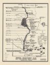
| Date: | 11 14 1942 |
|---|---|
| Description: | This pictorial map illustrates Potawatomi Indian legends from the region of Lower Phantom Lake, labeled Howitt Lake on the map, Phantom Lake, and Mukwonag... |

| Date: | 1915 |
|---|---|
| Description: | This 1915 map shows railroads, wagon roads, trails, creeks, rivers, lakes, and trout streams in Oneida and Lincoln counties within a 12 mile radius of Rhin... |

| Date: | 1930 |
|---|---|
| Description: | These 40 hand-drawn maps depict the survey townships in Oneida County, Wisconsin, on printed township grids. Lakes, rivers, and waterfront properties are d... |

| Date: | 1913 |
|---|---|
| Description: | This 1913 map of Pepin County, Wisconsin, shows the township and range grid, towns, villages, rural routes, railroads, roads, schools, churches, cemeteries... |

| Date: | 1922 |
|---|---|
| Description: | This map of Pepin County, Wisconsin, from the first half of the 20th century shows the township and range grid, towns, villages, railroads, roads, schools,... |

| Date: | 1925 |
|---|---|
| Description: | This map of Price County, Wisconsin, from the early 20th century shows the township and range system, towns, sections, cities and villages, railroads, high... |

| Date: | 1925 |
|---|---|
| Description: | This map of Price County, Wisconsin, from the early 20th century shows the township and range system, towns, sections, cities and villages, railroads, high... |

| Date: | 1934 |
|---|---|
| Description: | This 1934 map of Racine County, Wisconsin, shows the township and range grid, cities and villages, vegetation type, land use, roads, railroads, utilities, ... |
If you didn't find the material you searched for, our Library Reference Staff can help.
Call our reference desk at 608-264-6535 or email us at: